IMAGES TAKEN NEAR TO
Beech Road, LYDNEY, GL15 4TJ
Introduction
This page details the photographs taken nearby to Beech Road, GL15 4TJ by members of the Geograph project.
The Geograph project started in 2005 with the aim of publishing, organising and preserving representative images for every square kilometre of Great Britain, Ireland and the Isle of Man.

There are currently over 7.5m images from over14,400 individuals and you can help contribute to the project by visiting https://www.geograph.org.uk
Image Map
Images are licensed for reuse under creativecommons.org/licenses/by-sa/2.0
Notes
- Clicking on the map will re-center to the selected point.
- The higher the marker number, the further away the image location is from the centre of the postcode.
Image Listing (27 Images Found)
Images are licensed for reuse under creativecommons.org/licenses/by-sa/2.0
Image
Details
Distance
1
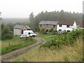
Arlin Cottages, Yorkley
Below Lower Road.
Image: © M J Richardson
Taken: 24 Sep 2013
0.06 miles
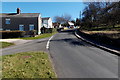
2
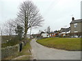
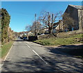
Beech Road, Yorkley
Part of the network of small roads in this Forest of Dean community.
Image: © Jonathan Billinger
Taken: 10 Mar 2010
0.09 miles
3
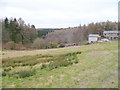
Forest edge at Yorkley
Looking north towards Bleek's Vallets from Yorkley Lower Road.
Image: © Jonathan Billinger
Taken: 10 Mar 2010
0.10 miles
4
Beech Road, Yorkley
Looking NNE from the edge of a former Baptist chapel. http://www.geograph.org.uk/photo/4417292
Image: © Jaggery
Taken: 16 Mar 2014
0.10 miles
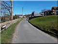
5
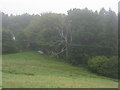
View from Lower Road, Yorkley
Field, woodland and a stored car.
Image: © M J Richardson
Taken: 24 Sep 2013
0.11 miles
6
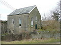
Old Baptist Chapel, Yorkley
Dated 1846, the building appears to be disused as of 2010.
Image: © Jonathan Billinger
Taken: 10 Mar 2010
0.12 miles
7
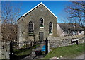
Former Baptist Chapel, Yorkley
The tablet on the Beech Road building shows BAPTIST CHAPEL 1868.
The chapel closed in 1980. The building has been converted to residential use.
http://www.geograph.org.uk/photo/4417301 to a side view.
Image: © Jaggery
Taken: 16 Mar 2014
0.12 miles
8
Corner of Stag Hill and Beech Road, Yorkley
Stag Hill is on the right.
Image: © Jaggery
Taken: 16 Mar 2014
0.12 miles
9
Lower Road, Yorkley
Looking NNE along Lower Road past the edge of a former Baptist Chapel http://www.geograph.org.uk/photo/4417301 on the right.
Image: © Jaggery
Taken: 16 Mar 2014
0.12 miles
10
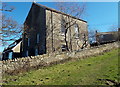
Lower Road side of a former Baptist Chapel, Yorkley
Viewed from a track ascending from Lower Road to Beech Road.
A tablet on the Beech Road side http://www.geograph.org.uk/photo/4417292 shows BAPTIST CHAPEL 1868.
The chapel closed in 1980. The building has been converted to residential use.
Image: © Jaggery
Taken: 16 Mar 2014
0.12 miles