IMAGES TAKEN NEAR TO
Viney Woodside, LYDNEY, GL15 4LX
Introduction
This page details the photographs taken nearby to GL15 4LX by members of the Geograph project.
The Geograph project started in 2005 with the aim of publishing, organising and preserving representative images for every square kilometre of Great Britain, Ireland and the Isle of Man.

There are currently over 7.5m images from over14,400 individuals and you can help contribute to the project by visiting https://www.geograph.org.uk
Image Map
Images are licensed for reuse under creativecommons.org/licenses/by-sa/2.0
Notes
- Clicking on the map will re-center to the selected point.
- The higher the marker number, the further away the image location is from the centre of the postcode.
Image Listing (34 Images Found)
Images are licensed for reuse under creativecommons.org/licenses/by-sa/2.0
Image
Details
Distance
1
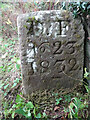
Boundary Marker, Pollard's Lane, Blakeney
Actually in the parish of Awre. In a private garden. By kind permission of the owner who thought they were gravestones until quite recently when they were photographed for a book. One of two in the same garden see Image
Inscription: D. F. / Nᴼ. 23 / 1832
Milestone Society National ID: GL_DFAWRE23em
Image: © Mr Red
Taken: 4 Oct 2022
0.03 miles
2
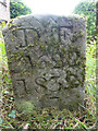
Boundary Stone, Pollard's Lane, Blakeney
Actually in the parish of Awre. In a private garden. By kind permission of the owner who thought they were gravestones until quite recently when they were photographed for a book. One of two in the same garden see Image
Inscription: D. F. / Nᴼ. 22 / 1832
Milestone Society National ID: GL_DFAWRE22em
Image: © Mr Red
Taken: 4 Oct 2022
0.04 miles
3
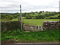
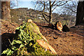
Stone Stile, Blakeney
On Gloucestershire footpath DAW63, off Pollards Lane looking from the road.
The view looking West is Image
Image: © Mr Red
Taken: 4 Oct 2022
0.05 miles
4
Stone Stile, Blakeney
On Gloucestershire footpath DAW63, off Pollards Lane looking towards the road. The view looking East is Image
Image: © Mr Red
Taken: 4 Oct 2022
0.05 miles
5
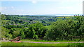
View over Blakeney
Looking east from the Viney Hill Road gives this far-reaching view across the Severn to the Cotswolds in the blue distance.
Image: © Jonathan Billinger
Taken: 8 Jun 2013
0.11 miles
6
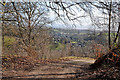
View from Viney Hill
Looking towards Blakeney in the distance.
Image: © Stuart Wilding
Taken: 9 Mar 2009
0.11 miles
7
View from Viney Hill
Looking towards Blakeney Hill in the distance.
Image: © Stuart Wilding
Taken: 9 Mar 2009
0.12 miles
8
Cottages on Viney Hill
Probably ex-quarry workers' dwellings.
Image: © Jonathan Billinger
Taken: 8 Jun 2013
0.14 miles
9
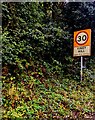
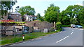
Viney Hill - Please drive carefully
On the southern approach to Viney Hill in the Forest of Dean
District in Gloucestershire, the National Speed Limit drops to 30mph.
Image: © Jaggery
Taken: 22 Oct 2023
0.15 miles
10
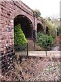
Disused Railway Viaduct, Blakeney
The Forest of Dean was covered by a large network of railways to carry the coal away.
Image: © Stuart Wilding
Taken: 29 Mar 2006
0.16 miles