IMAGES TAKEN NEAR TO
Cannop Road, LYDNEY, GL15 4JR
Introduction
This page details the photographs taken nearby to Cannop Road, GL15 4JR by members of the Geograph project.
The Geograph project started in 2005 with the aim of publishing, organising and preserving representative images for every square kilometre of Great Britain, Ireland and the Isle of Man.

There are currently over 7.5m images from over14,400 individuals and you can help contribute to the project by visiting https://www.geograph.org.uk
Image Map
Images are licensed for reuse under creativecommons.org/licenses/by-sa/2.0
Notes
- Clicking on the map will re-center to the selected point.
- The higher the marker number, the further away the image location is from the centre of the postcode.
Image Listing (40 Images Found)
Images are licensed for reuse under creativecommons.org/licenses/by-sa/2.0
Image
Details
Distance
1
Jon Daunter, Parkend
Cannop Road breakers of 4x4 vehicles, specialising in Range Rovers and Land Rovers.
The dismantled cars provide secondhand parts for sale.
Image: © Jaggery
Taken: 6 Apr 2014
0.00 miles
2
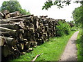
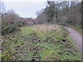
Timber stacks
Actually, there's more to this photo than some stacks of timber. This is the trackbed of the old Severn & Wye Railway which ran from Lydney to Cinderford via Parkend. The history of the line is enormously complicated, as it began as a tramway in about 1810 and was only converted to a "proper" railway because of quite a lot of political wrangling, but it seems that it existed as a standard gauge line by around 1870. The line to Cinderford was never really a success, and closed by 1951: however, this section of line remained open in order to allow trains to access the Coleford branch, which had lost its passenger service (along with the rest of the Severn & Wye system) in 1929 but remained open until 1967 for freight traffic, mostly stone from Whitecliff Quarry. This photo was shot roughly from the site of Coleford Junction looking back towards Parkend.
Image: © John Winder
Taken: 5 Oct 2019
0.03 miles
3
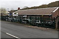
RMA Car Sales, Parkend
Cannop Road business.
Image: © Jaggery
Taken: 6 Apr 2014
0.03 miles
4
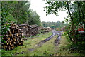
North of Parkend
This path runs alongside the old railway yard which, in the past, has been used to park 40ft containers but is now taken up with log storage. Note the disturbed earth in the foreground which we noticed in many locations in the Forest of Dean. These marks are made by the increasing numbers of wild boar in the Forest.
Image: © Paul E Smith
Taken: 21 Nov 2010
0.05 miles
5
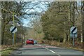
West Dean : Parkend - Cannop Road B4234
Looking along the B4234.
Image: © Lewis Clarke
Taken: 22 Mar 2023
0.05 miles
6
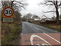
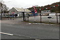
Please drive carefully in Parkend
The National Speed Limit along Cannop Road drops to 30mph.
Image: © Jaggery
Taken: 6 Apr 2014
0.05 miles
7
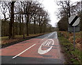
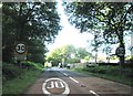
End of the 30 zone in Parkend
The B4234 Cannop Road heads into the Forest of Dean.
Image: © Jaggery
Taken: 6 Apr 2014
0.05 miles
9
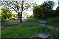
Hughes Terrace
Looking S.Southeast,up Hughes Terrace.The grass track on the right used to be the line of the former Railway.
Image: © jeff collins
Taken: 19 May 2009
0.07 miles