IMAGES TAKEN NEAR TO
Bathurst Road, GLOUCESTER, GL1 4RR
Introduction
This page details the photographs taken nearby to Bathurst Road, GL1 4RR by members of the Geograph project.
The Geograph project started in 2005 with the aim of publishing, organising and preserving representative images for every square kilometre of Great Britain, Ireland and the Isle of Man.

There are currently over 7.5m images from over14,400 individuals and you can help contribute to the project by visiting https://www.geograph.org.uk
Image Map
Images are licensed for reuse under creativecommons.org/licenses/by-sa/2.0
Notes
- Clicking on the map will re-center to the selected point.
- The higher the marker number, the further away the image location is from the centre of the postcode.
Image Listing (13 Images Found)
Images are licensed for reuse under creativecommons.org/licenses/by-sa/2.0
Image
Details
Distance
1
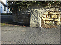
Old Boundary Stone B4072
On the Eastern side of the Stroud Road between 275 & 277. In the Linden/Tredworth/Tuffley area of Gloucester. It sits on the boundaries shown in maps 1887 to 1921, but on the other side of the road.
Milestone Society National ID: GL_GLOU04pb
Image: © Mr Red
Taken: 1 Nov 2021
0.09 miles
2
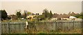
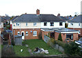
Allotments, Gloucester
Tredworth Field allotments glimpsed from the railway line, with houses on Bathurst Road and Hartland Road behind.
Image: © Derek Harper
Taken: 10 Apr 2015
0.11 miles
4
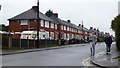
Off to the pub?
Two men on their way along Hartland Road on Christmas Eve, 2012.
Image: © Jonathan Billinger
Taken: 24 Dec 2012
0.16 miles

6
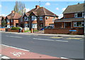
Stroud Road houses, Gloucester
Viewed from the corner of Tweenbrook Avenue. http://www.geograph.org.uk/photo/2905450
Image: © Jaggery
Taken: 13 Apr 2012
0.17 miles
8

Ribston Hall High School
Located in the very Roman-sounding Via Ribston. This girls' school dates back to the 19th century. http://www.ribstonhall.gloucs.sch.uk/page/?title=Our+History&pid=11 The school shares this road with Ribston Mews, a gated development.
Image: © HelenK
Taken: 30 Jul 2016
0.23 miles
9

South side of Tweenbrook Avenue, Gloucester
Viewed from the Stroud Road end.
http://www.geograph.org.uk/photo/2905451 to a view of the north side.
Image: © Jaggery
Taken: 13 Apr 2012
0.23 miles
10

North side of Tweenbrook Avenue, Gloucester
Viewed from the Stroud Road end.
http://www.geograph.org.uk/photo/2905450 to a view of the south side.
Image: © Jaggery
Taken: 13 Apr 2012
0.23 miles