IMAGES TAKEN NEAR TO
Victoria Street, GLOUCESTER, GL1 4EP
Introduction
This page details the photographs taken nearby to Victoria Street, GL1 4EP by members of the Geograph project.
The Geograph project started in 2005 with the aim of publishing, organising and preserving representative images for every square kilometre of Great Britain, Ireland and the Isle of Man.

There are currently over 7.5m images from over14,400 individuals and you can help contribute to the project by visiting https://www.geograph.org.uk
Image Map
Images are licensed for reuse under creativecommons.org/licenses/by-sa/2.0
Notes
- Clicking on the map will re-center to the selected point.
- The higher the marker number, the further away the image location is from the centre of the postcode.
Image Listing (183 Images Found)
Images are licensed for reuse under creativecommons.org/licenses/by-sa/2.0
Image
Details
Distance
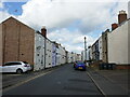
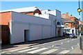
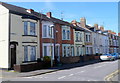
2
Pembroke Street, Gloucester
Looking to the southeast along Pembroke Street from the corner of Midland Road.
Image: © Jaggery
Taken: 6 Nov 2016
0.05 miles
3
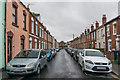
Blenheim Road
Victorian terraced housing off Barton Street.
Image: © Ian Capper
Taken: 16 Mar 2019
0.05 miles
4
Kurdistan Restaurant, Gloucester
The restaurant is the premises with the red door, at 156 Barton Street.
Image: © Jaggery
Taken: 13 Apr 2012
0.06 miles
5
Picturedrome Theatre, Gloucester
350-seat theatre, Barton Street, formerly the New Olympus Theatre.
Image: © Jaggery
Taken: 13 Apr 2012
0.06 miles
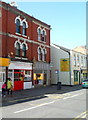
6
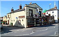
One Eyed Jacks, Gloucester
Pub on the corner of Barton Street and Victoria Street. The pub sign on this side shows one of the one-eyed jacks, the jack of spades. The jack of hearts, the other one-eyed jack, is on the reverse side.
Image: © Jaggery
Taken: 13 Apr 2012
0.06 miles
7
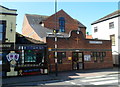
Barton Street Methodist Church, Gloucester
Located on Barton Street between Victoria Street and All Saints Road.
One Eyed Jacks http://www.geograph.org.uk/photo/2896679 is on the left.
Image: © Jaggery
Taken: 13 Apr 2012
0.06 miles
8
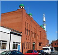
Jama Al-Karim Mosque, Gloucester
Viewed along All Saints Road. Islamic services had been held in a warehouse on this site since the late 1970s. The warehouse was demolished and replaced by the mosque in 1985.
Image: © Jaggery
Taken: 13 Apr 2012
0.06 miles
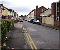
9
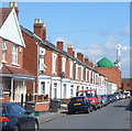
All Saints Road, Gloucester
Viewed from near the corner of Pembroke Street looking towards Jama Al-Karim Mosque. http://www.geograph.org.uk/photo/2902309
Image: © Jaggery
Taken: 13 Apr 2012
0.06 miles
10
Pembroke Street, Gloucester
Viewed from the corner of All Saints Road.
There are larger, semi-detached, houses on the opposite side of the street. http://www.geograph.org.uk/photo/2902328
Image: © Jaggery
Taken: 13 Apr 2012
0.07 miles