IMAGES TAKEN NEAR TO
St. Whites Road, CINDERFORD, GL14 3EZ
Introduction
This page details the photographs taken nearby to St. Whites Road, GL14 3EZ by members of the Geograph project.
The Geograph project started in 2005 with the aim of publishing, organising and preserving representative images for every square kilometre of Great Britain, Ireland and the Isle of Man.

There are currently over 7.5m images from over14,400 individuals and you can help contribute to the project by visiting https://www.geograph.org.uk
Image Map (Loading...)


Getting Data...Please wait
Leaflet Map data © OpenStreetMap
Images are licensed for reuse under creativecommons.org/licenses/by-sa/2.0
Notes
- Clicking on the map will re-center to the selected point.
- The higher the marker number, the further away the image location is from the centre of the postcode.
Image Listing (42 Images Found)
Images are licensed for reuse under creativecommons.org/licenses/by-sa/2.0
Image
Details
Distance
1
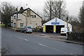
Cinderford Cash Wash
Car wash services such as this one in Cinderford appear to be springing up everywhere at present.
Image: © Philip Halling
Taken: 25 Jan 2014
0.00 miles
2
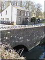
Cinderford Bridge
Carrying the B4226 over Cinderford Brook.
Image: © Pauline E
Taken: 11 Apr 2008
0.00 miles
3
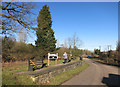
Ruspidge Halt, Forest of Dean
The halt closed in 1958 and the area was subsequently cleared but a short stone-built platform with a new nameboard, semaphore signal and 4-wheeled Berry Wiggins tank wagon now occupies the site. Bitumen traffic to Berry Wiggins at Whimsey kept the line open until 1967.
Image: © Ralph Rawlinson
Taken: 19 May 2002
0.02 miles
5
Ruspidge Halt
A local station on the Forest of Dean railway. It was opeed in 1907 and closed in 1958. http://en.wikipedia.org/wiki/Ruspidge_Halt_railway_station
The track is now a linear park.
Image: © Des Blenkinsopp
Taken: 4 Feb 2015
0.03 miles
6
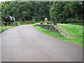
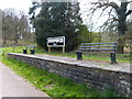
Ruspidge Halt railway station (site), Gloucestershire
Opened in 1907 by the Great Western Railway on their Forest of Dean branch line from Newnham-on-Severn to Coleford, this halt closed in 1958 but has been preserved. View south towards Staple Edge Halt and Newnham.
Image: © Nigel Thompson
Taken: 12 Sep 2013
0.03 miles
7
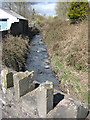
Cinderford Brook, from the bridge
This is an upstream view of the brook which runs through the Forest of Dean, eventually emptying into the Severn as Bideford Brook, east of Blakeney.
Image: © Pauline E
Taken: 11 Apr 2008
0.03 miles
8
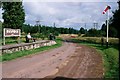
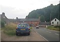
The B4226 entering Cinderford
The B4226 entering Ruspidge and Cinderford.
Image: © Philip Halling
Taken: 25 Jan 2014
0.03 miles
9
Junction of Valley Road and St Whites Road
Image: © Helen Steed
Taken: 4 Aug 2019
0.03 miles
10
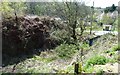
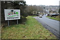
Cinderford Bridge Quarry from boundary with Wagstaff House
Overgrown remains of quarry at Cinderford Bridge, from boundary with Wagstaff House (once the offices for Cinderford Bridge Colliery). Once linked by rail to Ruspidge Halt. Image depicts junction with Valley Road, with bus stop in middle distance and Speech House Road (B4226) in background.
Image: © Clint Mann
Taken: 6 May 2013
0.04 miles