IMAGES TAKEN NEAR TO
Peacock Lane, CINDERFORD, GL14 3EU
Introduction
This page details the photographs taken nearby to Peacock Lane, GL14 3EU by members of the Geograph project.
The Geograph project started in 2005 with the aim of publishing, organising and preserving representative images for every square kilometre of Great Britain, Ireland and the Isle of Man.

There are currently over 7.5m images from over14,400 individuals and you can help contribute to the project by visiting https://www.geograph.org.uk
Image Map (Loading...)


Getting Data...Please wait
Leaflet Map data © OpenStreetMap
Images are licensed for reuse under creativecommons.org/licenses/by-sa/2.0
Notes
- Clicking on the map will re-center to the selected point.
- The higher the marker number, the further away the image location is from the centre of the postcode.
Image Listing (45 Images Found)
Images are licensed for reuse under creativecommons.org/licenses/by-sa/2.0
Image
Details
Distance
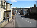
1
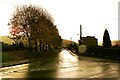
Railway Road, Ruspidge
A narrow lane leading down to the route of a former railway line.
Image: © Des Blenkinsopp
Taken: 24 Sep 2019
0.06 miles
2
St Whites Road, Cinderford
This is the B4226.
Image: © Pauline E
Taken: 11 Apr 2008
0.07 miles
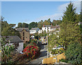
3
The Villa, Ruspidge, Forest of Dean
Towards the top or Northern end of Ruspidge road is a small local housing development called The Villa. Recently the frontage has been altered with a loss of part of the front gardens to make the pavement wider and vision for motorists better.
Image: © Eric Soons
Taken: 10 Nov 2008
0.07 miles
4
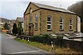
Wesleyan Chapel
This Wesleyan Chapel in Ruspidge dates from 1869 but I think it has been converted into residential housing.
Image: © Philip Halling
Taken: 25 Jan 2014
0.08 miles
5
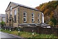
Wesleyan Chapel, Ruspidge, Forest of Dean
This former Wesleyan Chapel was built in 1869 but has within the last 5 years or so been converted to a private dwelling. It has a somewhat strange addition at the back that overlooks Cinderford brook and is now called Chapel House. It is within 50 metres or so of the Northern end of Railway road close to its junction with Speech House road.
Image: © Eric Soons
Taken: 11 Nov 2008
0.09 miles
6
Steve's Hairdressers, Ruspidge, Forest of Dean
This purpose-built hairdressing salon is very small, very friendly and very popular. It is located on the Western side of Ruspidge Road. This photo is facing the North.
Image: © Eric Soons
Taken: 9 Nov 2008
0.09 miles
7
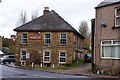
Bridge Inn, Cinderford, Forest of Dean
The Bridge Inn stands on the corner of Saint White's road and Valley road at the very South Western corner of Cinderford. It has now closed as an Inn or public house. The alley-like gravelled lane to the right of the Inn was a tram road, sometimes called locally a Dram Road. The roof, it is of a type called 'hipped, signifies that it is an important building - the only other one nearby is that of the one-time Mine Manager which still stands on a little knoll to the North East of the Bridge Inn.
Image: © Eric Soons
Taken: 11 Nov 2008
0.11 miles
8
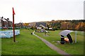
Recreational field, Ruspidge, Forest of Dean
The Recreational field at Ruspidge is very popular with the local children. The blue structure is a waist high maze for the very young whilst for the more sedate there is a covered modernistic bench, with associated waste bin. I don't know the purpose of the orange cone on top of the red pole ... but I'm sure it is very important.
Image: © Eric Soons
Taken: 10 Nov 2008
0.11 miles
9
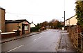
Ruspidge road looking South, Ruspidge, Forest of Dean
This is the South facing view of the junction of Saint White's road and Ruspidge road. Ruspidge road runs from this point due south to the 30-mile-an-hour exit-sign about a mile away.
Image: © Eric Soons
Taken: 9 Nov 2008
0.12 miles
10
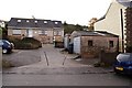
Brinton's Dairy, Ruspidge, Forest of Dean
Actually it is more of a milk delivery depot than a dairy. The small building with the 'up and over' door is where the milk is stored before being delivered to the doorsteps of customers. The dairy is located on the Eastern side of Ruspidge road.
Image: © Eric Soons
Taken: 9 Nov 2008
0.12 miles