IMAGES TAKEN NEAR TO
Ruspidge Road, CINDERFORD, GL14 3AR
Introduction
This page details the photographs taken nearby to Ruspidge Road, GL14 3AR by members of the Geograph project.
The Geograph project started in 2005 with the aim of publishing, organising and preserving representative images for every square kilometre of Great Britain, Ireland and the Isle of Man.

There are currently over 7.5m images from over14,400 individuals and you can help contribute to the project by visiting https://www.geograph.org.uk
Image Map
Images are licensed for reuse under creativecommons.org/licenses/by-sa/2.0
Notes
- Clicking on the map will re-center to the selected point.
- The higher the marker number, the further away the image location is from the centre of the postcode.
Image Listing (39 Images Found)
Images are licensed for reuse under creativecommons.org/licenses/by-sa/2.0
Image
Details
Distance
1
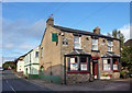
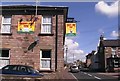
The New Inn, Ruspidge Road
A free house with some old fashioned etched glass windows on the side facing the road.
Image: © Des Blenkinsopp
Taken: 25 Sep 2019
0.01 miles
2
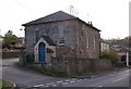
Bible Christian Chapel - Ruspidge, Forest of Dean
Originally built in 1857 the Bible Christian Chapel was one of the many small chapels built in the Forest. For a while it housed a mixture of fashion clothes and artworks and received its present name plate of 'Rainforest Chapel.'
Image: © Eric Soons
Taken: 28 Oct 2008
0.02 miles
4
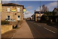
Ruspidge Road with two public houses
2004 view of Ruspidge Road (looking north) with The Rising Sun on left and The New Inn on the right.
Image: © Clint Mann
Taken: 12 Apr 2004
0.03 miles
5
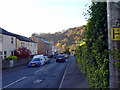
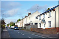
The Two Public Houses of Ruspidge - Forest of Dean
Looking up, to the North, along Ruspidge road towards Cinderford. On the left is the Rising Sun and almost immediately opposite the rival New Inn. Both public houses are lively and with a strong social life and either make a welcome break when exploring 'this neck of the woods.'
Image: © Eric Soons
Taken: 28 Oct 2008
0.04 miles
6
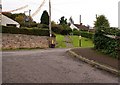
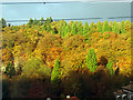
Granny Weavings Lane - Ruspidge
Between the two power poles is the uphill unadopted footpath known as Granny Weavings Lane. It link Tramway at the bottom with Buckshaft about 150 yards higher up the slope. Somewhat uniquely the footpath cuts into Buckshaft (which is shaped like a horizontal Z) and replaces the road surface with this one and a half metre wide hand-railed footpath. You cannot drive from one end of Buckshaft to the other because of the 'footpath' section in the middle !
Image: © Eric Soons
Taken: 28 Oct 2008
0.05 miles
8
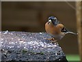
Brambling, Forest of Dean
An overwintering Brambling (Fringilla montifringilla) at one of my bird feeding sites in the garden.
Image: © Eric Soons
Taken: 24 Nov 2008
0.06 miles
9

Hewlett Way, Ruspidge
Looking down the unmettale portion of Hewlett Way, Ruspidge towards Grindles Lane, which is the local name for the hand-railed footpath connecting Buckshaft Road with Tramway Road.
Image: © Eric Soons
Taken: 22 Aug 2011
0.06 miles