IMAGES TAKEN NEAR TO
Newtown Road, CINDERFORD, GL14 2YT
Introduction
This page details the photographs taken nearby to Newtown Road, GL14 2YT by members of the Geograph project.
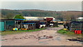
The Geograph project started in 2005 with the aim of publishing, organising and preserving representative images for every square kilometre of Great Britain, Ireland and the Isle of Man.

There are currently over 7.5m images from over14,400 individuals and you can help contribute to the project by visiting https://www.geograph.org.uk
Image Map
Images are licensed for reuse under creativecommons.org/licenses/by-sa/2.0
Notes
- Clicking on the map will re-center to the selected point.
- The higher the marker number, the further away the image location is from the centre of the postcode.
Image Listing (39 Images Found)
Images are licensed for reuse under creativecommons.org/licenses/by-sa/2.0
Image
Details
Distance
1
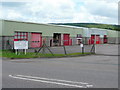
Broadmoor Park industrial units
Part of the industrial sprawl to the west of Cinderford.
Image: © Jonathan Billinger
Taken: 7 Aug 2009
0.02 miles
2
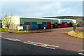
Units in Broadmoor Park, Cinderford
Viewed across the B4227 Broadmoor Road. The board on the left lists the businesses in the park and their locations.
Image: © Jaggery
Taken: 16 Dec 2012
0.04 miles
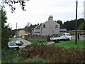
3
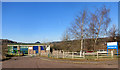
Forest Dialysis Unit
From Healthwatch Gloucestershire :-
"The Forest Dialysis Unit is a brand new kidney care centre on the Forest Vale Industrial Estate in Cinderford. Supported by partner organisations NHS Gloucestershire and the Forest of Dean District Council, the Trust’s new unit has state of the art dialysis machines and has capacity for forty eight patients with twelve dialysis stations."
Image: © Des Blenkinsopp
Taken: 9 Feb 2015
0.06 miles
4
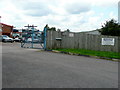
Car parts recycling
A breaker's yard at Broadmoor specialising in BMW.
Image: © Jonathan Billinger
Taken: 7 Aug 2009
0.06 miles
5

Some posters
The wooden fence on the corner of Broadmoor Road and Steam Mills Road seems to be an unofficial information point. They provide a small snapshot of Forest life.
Image: © Jonathan Billinger
Taken: 7 Aug 2009
0.08 miles
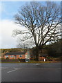
6
B4227 Broadmoor Road junction
Looking north along Steam Mills Road north of Cinderford.
Image: © Jonathan Billinger
Taken: 7 Aug 2009
0.08 miles
7
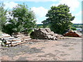
Traditional forest industry
Piles of logs from the Forest of Dean waiting to be turned into fencing panels at Broadmoor Sawmills.
Image: © Jonathan Billinger
Taken: 7 Aug 2009
0.08 miles
8
Steam Mills Road
With Haywood Plantation behind.
Image: © Jennifer Luther Thomas
Taken: 27 Oct 2006
0.09 miles
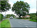
9
Dominant tree at a road junction in Cinderford
Viewed from Broadmoor Road looking towards Steam Mills Road.
Image: © Jaggery
Taken: 16 Dec 2012
0.09 miles
10
Broadmoor, Cinderford
Industrial land-use to the north of Cinderford with the Forest of Dean beyond.
Image: © Jonathan Billinger
Taken: 23 Nov 2012
0.11 miles