IMAGES TAKEN NEAR TO
Rosedale Court, CINDERFORD, GL14 2TL
Introduction
This page details the photographs taken nearby to Rosedale Court, GL14 2TL by members of the Geograph project.
The Geograph project started in 2005 with the aim of publishing, organising and preserving representative images for every square kilometre of Great Britain, Ireland and the Isle of Man.

There are currently over 7.5m images from over14,400 individuals and you can help contribute to the project by visiting https://www.geograph.org.uk
Image Map
Images are licensed for reuse under creativecommons.org/licenses/by-sa/2.0
Notes
- Clicking on the map will re-center to the selected point.
- The higher the marker number, the further away the image location is from the centre of the postcode.
Image Listing (174 Images Found)
Images are licensed for reuse under creativecommons.org/licenses/by-sa/2.0
Image
Details
Distance
1
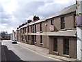
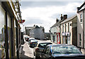
Victoria Street, Cinderford
Looking SSW along the road that for 1100 yards "was made at the expense of the crown for the benefit of the inhabitants and district" in 1897-8, Queen victoria's Diamond Jubilee.
Image: © Bob Embleton
Taken: 5 Mar 2006
0.04 miles
2
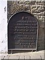
Victoria Street Plaque
At the northern end of Victoria Street explaining its connection with the Crown.
Image: © Bob Embleton
Taken: 5 Mar 2006
0.04 miles
3
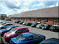
Ex-college building, Cinderford
View from College Road. Now superseded by the Royal Forest of Dean campus at Five Acres, Coleford.
Image: © Jonathan Billinger
Taken: 7 Aug 2009
0.06 miles
4
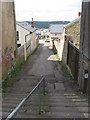
Steps off Market Street
Considering this is such a hilly place, I didn't come across many steps.
Image: © Pauline E
Taken: 17 Mar 2008
0.06 miles
5
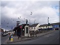
Cinderford Town Centre and War Memorial
Looking north just as the flock of birds flew over.
Image: © Bob Embleton
Taken: 5 Mar 2006
0.08 miles
6
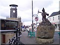
Cinderford Town Centre and the Miners' Memorial
On the memorial, sculpted by Antony Dufort, a plaque says that this was commissioned in the year 2000 as "A Tribute To The Miners Of The Forest Of Dean".
Image: © Bob Embleton
Taken: 5 Mar 2006
0.08 miles
7
Corner of Victoria Street and Commercial Street, Cinderford
This view was taken from the point where Market Street behind the camera splits into Victoria Street (on the right) and Commercial Street. The building on the corner is the Soldiers and Sailors Club. http://www.geograph.org.uk/photo/3265938
Image: © Jaggery
Taken: 16 Dec 2012
0.08 miles
8
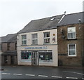
Cinderford Angling Shop
Located on the edge of the town centre at 3 Victoria Street.
Image: © Jaggery
Taken: 16 Dec 2012
0.09 miles
9
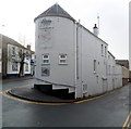
Soldiers & Sailors Club, Commercial Street, Cinderford
A distinctive building at the apex of Commercial Street and Victoria Street.
Image: © Pauline E
Taken: 17 Mar 2008
0.09 miles
10
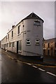
Soldiers and Sailors Club, Cinderford, Forest of Dean
This tall, narrow building is crammed into the thin wedge of land as Victoria Street joins Commercial Street. The Soldiers and Sailors Club has been a landmark in Cinderford for many decades.
Image: © Eric Soons
Taken: 10 Nov 2008
0.09 miles