IMAGES TAKEN NEAR TO
Southwood Close, CINDERFORD, GL14 2PR
Introduction
This page details the photographs taken nearby to Southwood Close, GL14 2PR by members of the Geograph project.
The Geograph project started in 2005 with the aim of publishing, organising and preserving representative images for every square kilometre of Great Britain, Ireland and the Isle of Man.

There are currently over 7.5m images from over14,400 individuals and you can help contribute to the project by visiting https://www.geograph.org.uk
Image Map (Loading...)


Getting Data...Please wait
Leaflet Map data © OpenStreetMap
Images are licensed for reuse under creativecommons.org/licenses/by-sa/2.0
Notes
- Clicking on the map will re-center to the selected point.
- The higher the marker number, the further away the image location is from the centre of the postcode.
Image Listing (155 Images Found)
Images are licensed for reuse under creativecommons.org/licenses/by-sa/2.0
Image
Details
Distance
1
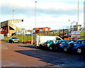
The Beavis Memorial Ground, Cinderford
Viewed from the Dockham Road side. This is the home ground of Cinderford Rugby Football Club.
Image: © Jaggery
Taken: 16 Dec 2012
0.05 miles
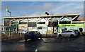
2
Cinderford Rugby Football Club, founded 1886
The Recreation Ground, Dockham Road. Soon to move to St. Whites Ground.
Image: © Pauline E
Taken: 17 Mar 2008
0.06 miles
3
Co-operative Food, Travel and Cinderford post office
Set back from the north side of Dockham Road in Cinderford town centre.
Co-operative Travel and the post office are inside the food store.
Image: © Jaggery
Taken: 16 Dec 2012
0.07 miles
4
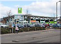
Co-op food store, Cinderford
Plans for a Tesco superstore and a new rugby club ground were approved by planners in 2005 and were then challenged by the Co-op which is next door to the proposed site for Tesco's new store.
Image: © Pauline E
Taken: 17 Mar 2008
0.07 miles
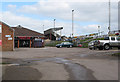
5
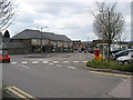
Bus station, Dockham Road, Cinderford
Next to the Co-op store, health centre and post office.
Image: © Pauline E
Taken: 17 Mar 2008
0.09 miles
6
Pets Barn entrance, Cinderford
Viewed across Heywood Road. The yellow-on-green name board shows
Pets Barn Forest of Dean veterinary centre & animal hospital.
Image: © Jaggery
Taken: 16 Dec 2012
0.09 miles
7
Cinderford Bus Station
Shown on maps as Cinderford Bus Station, the reality is two bus shelters alongside an area set back from the north side of Dockham Road. Cinderford formerly had a proper bus station, demolished in the late 1980s.
Image: © Jaggery
Taken: 16 Dec 2012
0.10 miles
8
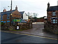
Heywood Road, Cinderford
North of the Trinity Way junction. http://www.geograph.org.uk/photo/4426864
Image: © Jaggery
Taken: 12 Apr 2015
0.10 miles
9
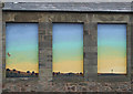
They used to be windows
I'm not certain but this looks like the back of Wesley Hall, Cinderford. If you know anything about these colourful murals, let me know and I will update the information.
Image: © Pauline E
Taken: 17 Mar 2008
0.11 miles
10
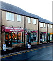
Muzo's of Cinderford
Muzo's cafe bar & restaurant is in Dockham Road. Next door is Cutting Edge hair & beauty salon.
Image: © Jaggery
Taken: 16 Dec 2012
0.11 miles