IMAGES TAKEN NEAR TO
Station Street, CINDERFORD, GL14 2JT
Introduction
This page details the photographs taken nearby to Station Street, GL14 2JT by members of the Geograph project.
The Geograph project started in 2005 with the aim of publishing, organising and preserving representative images for every square kilometre of Great Britain, Ireland and the Isle of Man.

There are currently over 7.5m images from over14,400 individuals and you can help contribute to the project by visiting https://www.geograph.org.uk
Image Map (Loading...)


Getting Data...Please wait
Leaflet Map data © OpenStreetMap
Images are licensed for reuse under creativecommons.org/licenses/by-sa/2.0
Notes
- Clicking on the map will re-center to the selected point.
- The higher the marker number, the further away the image location is from the centre of the postcode.
Image Listing (173 Images Found)
Images are licensed for reuse under creativecommons.org/licenses/by-sa/2.0
Image
Details
Distance
1
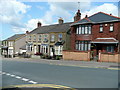
Station Road, Cinderford
Housing of varying styles and ages.
Image: © Jonathan Billinger
Taken: 7 Aug 2009
0.04 miles
2
Ex-college building, Cinderford
View from College Road. Now superseded by the Royal Forest of Dean campus at Five Acres, Coleford.
Image: © Jonathan Billinger
Taken: 7 Aug 2009
0.06 miles
3
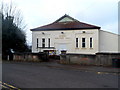
Miners Welfare Hall, Cinderford
Viewed across Wesley Road. The back of the hall faces Parragate Road.
Now used as a community hall and dance hall.
Image: © Jaggery
Taken: 16 Dec 2012
0.08 miles
4
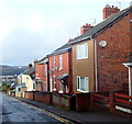
Parragate Road, Cinderford
Viewed from the Wesley Road and High Street end looking west.
According to various sources, this is the only Parragate Road in the UK.
Image: © Jaggery
Taken: 16 Dec 2012
0.08 miles
5
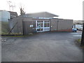
Cinderford Telephone Exchange, Glos
Situated in Station Street, this TE is of a standard design dating from the late 1960s, and has the code SSCIN. It provides telephone and broadband services to 5,180 residential and 363 non-residential premises in Cinderford plus Littledean, Ruspidge and Upper Soudley nearby. The numbering range of this TE is (01594) 82xxxx, the (01594) referring to the Lydney group of nine TEs, and its postcode is GL14 2JW.
Image: © David Hillas
Taken: 10 Jan 2018
0.08 miles
6
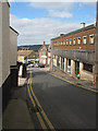
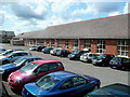
Station Street, Cinderford
The cars are parked outside the police station.
Image: © Pauline E
Taken: 17 Mar 2008
0.08 miles
7
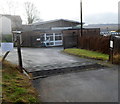
Cattle grid protects Cinderford telephone exchange
The location is Station Street opposite the police station. http://www.geograph.org.uk/photo/3653306
Image: © Jaggery
Taken: 16 Dec 2012
0.09 miles
8
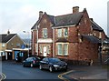
Cinderford police station
The year 1877 is inscribed on the police station in Station Street.
Image: © Jaggery
Taken: 16 Dec 2012
0.09 miles
9
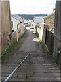
Steps off Market Street
Considering this is such a hilly place, I didn't come across many steps.
Image: © Pauline E
Taken: 17 Mar 2008
0.10 miles
10
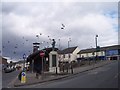
Cinderford Town Centre and War Memorial
Looking north just as the flock of birds flew over.
Image: © Bob Embleton
Taken: 5 Mar 2006
0.10 miles