IMAGES TAKEN NEAR TO
Wesley Road, CINDERFORD, GL14 2JN
Introduction
This page details the photographs taken nearby to Wesley Road, GL14 2JN by members of the Geograph project.
The Geograph project started in 2005 with the aim of publishing, organising and preserving representative images for every square kilometre of Great Britain, Ireland and the Isle of Man.

There are currently over 7.5m images from over14,400 individuals and you can help contribute to the project by visiting https://www.geograph.org.uk
Image Map (Loading...)


Getting Data...Please wait
Leaflet Map data © OpenStreetMap
Images are licensed for reuse under creativecommons.org/licenses/by-sa/2.0
Notes
- Clicking on the map will re-center to the selected point.
- The higher the marker number, the further away the image location is from the centre of the postcode.
Image Listing (178 Images Found)
Images are licensed for reuse under creativecommons.org/licenses/by-sa/2.0
Image
Details
Distance
1
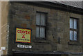
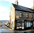
The confidence of the ad man
The yellow sign advertises the Craven A brand of cigarettes and the strap line reads, 'Will not affect your throat'. I wonder how long that's been there!
Image: © Pauline E
Taken: 17 Mar 2008
0.02 miles
2
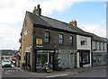
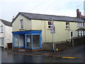
Traditional greengrocer, High Street, Cinderford
There are lots of independent retailers in the town. This one is Keith's, at the junction of High Street and Wesley Road.
Image: © Pauline E
Taken: 17 Mar 2008
0.02 miles
3
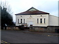
Miners Welfare Hall, Cinderford
Viewed across Wesley Road. The back of the hall faces Parragate Road.
Now used as a community hall and dance hall.
Image: © Jaggery
Taken: 16 Dec 2012
0.02 miles
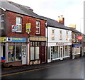
4
Corner of High Street and Wesley Road in Cinderford
The High Street shops are Keith's Greengrocer and The Powder Puff nails & beauty salon.
Image: © Jaggery
Taken: 16 Dec 2012
0.03 miles
5
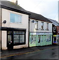
Ark Property Management office in Cinderford
Ark is the green premises at 44A High Street.
Image: © Jaggery
Taken: 16 Dec 2012
0.03 miles
6
Exodus in Cinderford
Exodus in the middle of the view is a High Street hair salon. Its neighbours are Computer House on the left and The Jolly Forest Fryer http://www.geograph.org.uk/photo/3748969 on the right.
Image: © Jaggery
Taken: 16 Dec 2012
0.04 miles
7
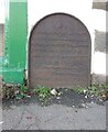
Commemorative Plate, Cinderford
On the wall of an empty shop at the junction of High Street and Wesley Road. An older image showing the plaque when the shop was a greengocer's is Image
E.Stafford Howard was MP for Thornbury 1885/6. Served as Under-Secretary of State for India under William Ewart Gladstone. Later Senior Commissioner of HM's Woods and Forests.
Inscription:
V (crown) R
This road for the distance
of 670 ↢ yards was made
at the expense of the crown
for the benefit of the
inhabitants and district
1897 - 8
E.Stafford Howard Esq
Commissioner
Philip Baylis Esq
Dep Surveyor
Milestone Society National ID: GL_CIND06cm
Image: © Mr Red
Taken: 18 Nov 2022
0.04 miles
8
Empty shop on the corner of High Street and Marshalls Lane Cinderford
Formerly an office of Mark Harper, Member of Parliament for the Forest of Dean.
Image: © Jaggery
Taken: 16 Dec 2012
0.04 miles
9
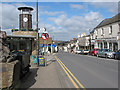
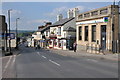
High Street, Cinderford
Cinderford is a small, historic market town with a population of approximately 7500, situated in an elevated position on the eastern edge of the Forest of Dean and almost surrounded by forest. The original settlement in the area was a small collection of houses, known as "encroachment" cottages built at the end of the 18th century, along the edge of the forest boundary. The cottages were built just inside the forest, at a time when it was illegal to build houses on the land of the Royal Forest. Today, Cinderford is one of the main commercial centres of the Forest of Dean, and has a good range of independent shops and an open air market. There are also 20+ local pubs, cafes and restaurants. This shows the High Street, looking north towards Steam Mills.
Image: © Pauline E
Taken: 17 Mar 2008
0.04 miles