IMAGES TAKEN NEAR TO
Office Road, CINDERFORD, GL14 2HZ
Introduction
This page details the photographs taken nearby to Office Road, GL14 2HZ by members of the Geograph project.
The Geograph project started in 2005 with the aim of publishing, organising and preserving representative images for every square kilometre of Great Britain, Ireland and the Isle of Man.

There are currently over 7.5m images from over14,400 individuals and you can help contribute to the project by visiting https://www.geograph.org.uk
Image Map
Images are licensed for reuse under creativecommons.org/licenses/by-sa/2.0
Notes
- Clicking on the map will re-center to the selected point.
- The higher the marker number, the further away the image location is from the centre of the postcode.
Image Listing (16 Images Found)
Images are licensed for reuse under creativecommons.org/licenses/by-sa/2.0
Image
Details
Distance
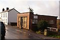
1
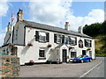
The Forge Hammer Inn, Cinderford
On a bend in Victoria Street, to the south of the town centre.
Image: © Jonathan Billinger
Taken: 7 Aug 2009
0.06 miles
2
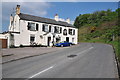
The Forge Hammer Inn
The Forge Hammer Inn in Cinderford.
Image: © Philip Halling
Taken: 25 Apr 2011
0.06 miles
3
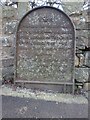
Commemorative Plate, Cinderford
At the bottom of Victoria Road on the SE side at Valley Road, B4227.
This is the companion to the plaque at the NE end of the road, see Image
Inscription:
V (crown) R
This road for the distance
of 1100 ↢ yards was made
at the expense of the crown
for the benefit of the
inhabitants and district
1897 - 8
E.Stafford Howard Esq
Commissioner
Philip Baylis Esq
Dep Sur
Milestone Society National ID: tbc
Image: © Mr Red
Taken: 26 Feb 2024
0.10 miles
4
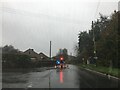
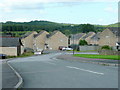
Albert Road, Cinderford
Affordable housing in this cul-de-sac to the south-west of the town centre.
The Forest can be seen beyond.
Image: © Jonathan Billinger
Taken: 7 Aug 2009
0.10 miles
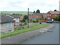
6
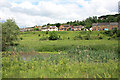
Houses above Valley Road, Cinderford
They have a lovely view over the ponds at Linear Park and into the forest.
Image: © Pauline E
Taken: 9 Jun 2010
0.13 miles
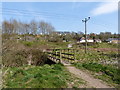
8
The Telecottage, Cinderford, Forest of Dean
Standing on its own small patch of flat ground built on the very edge of the valley's steep side, the Telecottage is still in business and is possibly the oldest computer business in Cinderford.
Image: © Eric Soons
Taken: 10 Nov 2008
0.16 miles
9
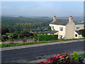
View from Church Road, Cinderford
Church Road is terraced along the side of a valley, with many houses having this fine westerly view over the Forest of Dean.
Image: © Des Blenkinsopp
Taken: 9 Oct 2010
0.18 miles
10
Hastings Road, Cinderford
Affordable new-ish housing with a view to the Forest of Dean.
Image: © Jonathan Billinger
Taken: 7 Aug 2009
0.19 miles