IMAGES TAKEN NEAR TO
Hastings Road, CINDERFORD, GL14 2HN
Introduction
This page details the photographs taken nearby to Hastings Road, GL14 2HN by members of the Geograph project.
The Geograph project started in 2005 with the aim of publishing, organising and preserving representative images for every square kilometre of Great Britain, Ireland and the Isle of Man.

There are currently over 7.5m images from over14,400 individuals and you can help contribute to the project by visiting https://www.geograph.org.uk
Image Map (Loading...)


Getting Data...Please wait
Leaflet Map data © OpenStreetMap
Images are licensed for reuse under creativecommons.org/licenses/by-sa/2.0
Notes
- Clicking on the map will re-center to the selected point.
- The higher the marker number, the further away the image location is from the centre of the postcode.
Image Listing (15 Images Found)
Images are licensed for reuse under creativecommons.org/licenses/by-sa/2.0
Image
Details
Distance
1
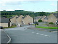
Hastings Road, Cinderford
Affordable new-ish housing with a view to the Forest of Dean.
Image: © Jonathan Billinger
Taken: 7 Aug 2009
0.05 miles
2
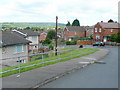
Albert Road, Cinderford
Affordable housing in this cul-de-sac to the south-west of the town centre.
The Forest can be seen beyond.
Image: © Jonathan Billinger
Taken: 7 Aug 2009
0.10 miles
3
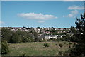
Houses on Valley Road
Taken from the old railway between Bullo and Cinderford, now a footpath and cycle track. The houses in the centre are on Valley Road, with Cinderford spread out on the hillside in the background.
Image: © John Winder
Taken: 24 May 2020
0.14 miles
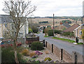
4
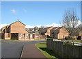
Housing estate, Cinderford
On the horizon, the Baptist Chapel in Commercial Street, encased in scaffolding. Image
Image: © Pauline E
Taken: 11 Apr 2008
0.19 miles
5
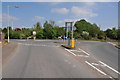
Roundabout on Happy Road, Cinderford
Roundabout on the B4227, Happy Road in Cinderford.
Image: © Philip Halling
Taken: 25 Apr 2011
0.21 miles
6
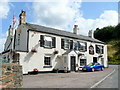
The Forge Hammer Inn, Cinderford
On a bend in Victoria Street, to the south of the town centre.
Image: © Jonathan Billinger
Taken: 7 Aug 2009
0.21 miles
7
View towards the forest from The Prospect
Thanks to its elevated position, many houses in Cinderford enjoy fine views.
Image: © Pauline E
Taken: 17 Mar 2008
0.21 miles
8
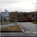
Valley Road distances from the south of Cinderford
The B4227 Valley Road heads south away from Cinderford towards Dilke Hospital (1⅓ miles)
Ruspidge (1½) and Speech House (3). The sign is positioned facing vehicles on a roundabout.
Image: © Jaggery
Taken: 16 Dec 2012
0.21 miles
9
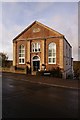
Methodist Chapel, Cinderford, Forest of Dean
The Primitive Methodist Chapel was built in 1864 but has recently (2008) been converted to a block of 5 apartments which are collectively called Chapel Court.
Image: © Eric Soons
Taken: 10 Nov 2008
0.21 miles
10
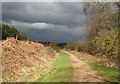
Heavy shower approaching
Walking along the route of a former GWR line in Cinderford Linear Park - towards Bilson Halt. At different times, tramroads, a tramway, a canal and railways proliferated in this valley.
Image: © Pauline E
Taken: 13 Apr 2008
0.22 miles