IMAGES TAKEN NEAR TO
Packers Road, CINDERFORD, GL14 2DX
Introduction
This page details the photographs taken nearby to Packers Road, GL14 2DX by members of the Geograph project.
The Geograph project started in 2005 with the aim of publishing, organising and preserving representative images for every square kilometre of Great Britain, Ireland and the Isle of Man.

There are currently over 7.5m images from over14,400 individuals and you can help contribute to the project by visiting https://www.geograph.org.uk
Image Map
Images are licensed for reuse under creativecommons.org/licenses/by-sa/2.0
Notes
- Clicking on the map will re-center to the selected point.
- The higher the marker number, the further away the image location is from the centre of the postcode.
Image Listing (118 Images Found)
Images are licensed for reuse under creativecommons.org/licenses/by-sa/2.0
Image
Details
Distance
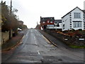
1
Forest Road, Cinderford
At its junction with Packers Road.
Image: © Pauline E
Taken: 17 Mar 2008
0.03 miles
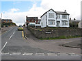
2
Forest Road, Cinderford
Forest Road climbs away from Commercial Street past the northern edge of Packers Road.
Image: © Jaggery
Taken: 16 Dec 2012
0.04 miles
3
Four aerials, four flats, Forest Road, Cinderford
Four aerials are on top of the pyramid-like roof of flats near the Woodside Street junction.
Image: © Jaggery
Taken: 12 Apr 2015
0.06 miles
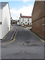
4

Alley near the Baptist Church
In my home county this would be known as a snicket - others may call it an alley, a ginnel or a jigger. It links Commercial Street with Victoria Street.
Image: © Pauline E
Taken: 17 Mar 2008
0.07 miles
5
Entrance to the Baptist Chapel, Commercial Street
The chapel was built in 1860 by the Bible Christian Chapel for the workmen's community.
Image: © Pauline E
Taken: 17 Mar 2008
0.07 miles
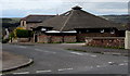
6
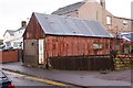
Rusty shed, Cinderford, Forest of Dean
Derelict, empty or abandoned - this rusty shed is what greets the congregation of the Baptist Church as they leave their Sunday services. It is a mixture, now, of rusty corrugated iron, cement and breeze block and is completely boarded up with a one-time mail slot in the wall blocked up. The roof, surprisingly, has had new corrugated iron sheets fixed along with a proper ridge capping. Perhaps, it is an investment waiting to mature.
Image: © Eric Soons
Taken: 11 Nov 2008
0.07 miles
7
Lamb Lane, Cinderford
Linking Commercial Street with Woodside Street.
Image: © Pauline E
Taken: 17 Mar 2008
0.07 miles
8
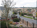
View towards the forest from The Prospect
Thanks to its elevated position, many houses in Cinderford enjoy fine views.
Image: © Pauline E
Taken: 17 Mar 2008
0.08 miles
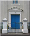
9
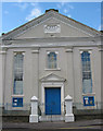
Facade of the Baptist Chapel, Cinderford
Built in 1860 by the Bible Christian Chapel for the workmen's community.
Image: © Pauline E
Taken: 17 Mar 2008
0.08 miles
10
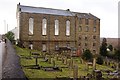
Baptist Church, Cinderford, Forest of Dean
High on the ridge that runs from the centre of Cinderford due South to Ruspidge stands the 5-storey Baptist church that was built by the citizens of the town in 1860. In its hey-day there were Sunday schools, Bible meetings and services throughout the very large building. The photograph shows a goodly part of the graveyard that slopes down towards the valley bottom.
Image: © Eric Soons
Taken: 11 Nov 2008
0.08 miles