IMAGES TAKEN NEAR TO
Littledean Road, NEWNHAM, GL14 1JY
Introduction
This page details the photographs taken nearby to Littledean Road, GL14 1JY by members of the Geograph project.
The Geograph project started in 2005 with the aim of publishing, organising and preserving representative images for every square kilometre of Great Britain, Ireland and the Isle of Man.

There are currently over 7.5m images from over14,400 individuals and you can help contribute to the project by visiting https://www.geograph.org.uk
Image Map
Images are licensed for reuse under creativecommons.org/licenses/by-sa/2.0
Notes
- Clicking on the map will re-center to the selected point.
- The higher the marker number, the further away the image location is from the centre of the postcode.
Image Listing (6 Images Found)
Images are licensed for reuse under creativecommons.org/licenses/by-sa/2.0
Image
Details
Distance
1
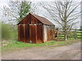
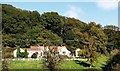
Old corrugated iron shed
This shed is at the beginning of the track to Grove Farm.
Image: © Tony Bailey
Taken: 21 Apr 2006
0.07 miles
2
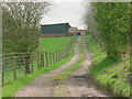
Track to Grove Farm
This track leads from the A4151 up to Grove Farm and then on to The Grove (a private dwelling). To the right and up the hill is an ancient earthwork.
Image: © Tony Bailey
Taken: 21 Apr 2006
0.08 miles
3
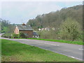
1 and 2 Model Cottage
Quaintly named cottages on the A4151 with Chestnut Hill in the background
Image: © Tony Bailey
Taken: 21 Apr 2006
0.18 miles
4
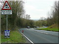
A4151 east of Littledean
The sign points the way to the Greyhound Inn, a little further along this road.
See Image
Image: © Jonathan Billinger
Taken: 31 Dec 2009
0.20 miles
5
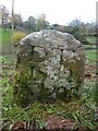
Old Boundary Stone,
In a field North of the A4151, just beyond the dead end of a Public Right of Way.
It marks the boundary of the "Forest of Dean", and is on the boundary of East Dean and Littledean (1950 parishes).
Inscription: D. F / 1832 / Nᴼ. 203
Milestone Society National ID: GL_DFLITT203em
Image: © Mr Red
Taken: 5 Dec 2022
0.23 miles