
IMAGES TAKEN NEAR TO
New Road, NEWNHAM, GL14 1JT
Introduction
This page details the photographs taken nearby to New Road, GL14 1JT by members of the Geograph project.
The Geograph project started in 2005 with the aim of publishing, organising and preserving representative images for every square kilometre of Great Britain, Ireland and the Isle of Man.

There are currently over 7.5m images from over14,400 individuals and you can help contribute to the project by visiting https://www.geograph.org.uk
Image Map
Images are licensed for reuse under creativecommons.org/licenses/by-sa/2.0
Notes
- Clicking on the map will re-center to the selected point.
- The higher the marker number, the further away the image location is from the centre of the postcode.
Image Listing (16 Images Found)
Images are licensed for reuse under creativecommons.org/licenses/by-sa/2.0
Image
Details
Distance
1
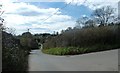
Pope's Hill road junction
Junction of two minor roads: road connecting Flaxley to A4151 (Elton Road) and The Slad (leads to upper part of Pope's Hill).
Image: © Clint Mann
Taken: 15 Mar 2014
0.03 miles
2
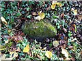
Old Boundary Stone, Blakemore Hale
On the SE side of a track belonging to Blakemore's Hale. It marks the boundary of the "Forest of Dean", and is on the boundary of East Dean and Westbury on Severn (1950 parishes).
Inscription: D. F / 1832 / Nᴼ. 200
Milestone Society National ID: GL_DFLIWS200em
Image: © Mr Red
Taken: 6 Dec 2022
0.11 miles
3
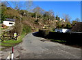
Minor road north of the A4151 Elton Road in Pope's Hill
Toward Blakemore Farm.
Image: © Jaggery
Taken: 1 Mar 2015
0.13 miles
4
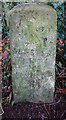
Old Milestone opposite Cherry Tree Farm,
Carved stone post by the A4151, in parish of WESTBURY ON SEVERN (FOREST OF DEAN District),
behind railings, on the North side of road. The carved Benchmark represents 47.3 m ASL.
EC stone, erected by the Forest of Dean turnpike trust in the 19ᵗʰ century.
An earlier image is Image
Inscription reads: COLEFORD / 8 / GLOSTER / 11 / LONDON / (??)
Milestone Society National ID: GL_ELCO02
Image: © Mr Red
Taken: 5 Dec 2022
0.14 miles
5
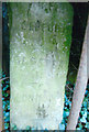
Old Milestone by the A4151, Cherry Tree Farm, Westbury on Severn parish
Carved stone post by the A4151, in parish of WESTBURY ON SEVERN (FOREST OF DEAN District), opposite Cherry Tree Farm, behind railings, on North side of road. EC stone, erected by the Forest of Dean turnpike trust in the 19th century.
Inscription reads:-
COLEFORD
8
GLOSTER
11
LONDON
(??)
Carved bench mark on face.
Milestone Society National ID: GL_ELCO02.
Image: © K Walker & R Harvey
Taken: 18 Mar 2003
0.15 miles
6
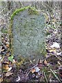
Boundary Stone, A4151 Elton
Opposite New Road, on the verge set back from the highway. The inscription is of 1832 but the typeface is not Victorian.
It may be that a replacement stone was installed after road widening and bend easing (deduced comparing old maps).
It marks the boundary of the "Forest of Dean", and is on the boundary of East Dean and Westbury on Severn (1950 parishes).
Inscription: D. F / 1832 / Nᴼ. 201
Milestone Society National ID: GL_DFLIWS201em
Image: © Mr Red
Taken: 6 Dec 2022
0.16 miles
7
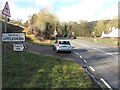
Eastern boundary of Littledean Parish
Alongside the A4151 Elton Road in Pope's Hill east of the village of Littledean.
This is one of several dozen parishes in the Forest of Dean District.
Image: © Jaggery
Taken: 1 Mar 2015
0.17 miles
8
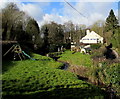
Stream through the garden of The Greyhound Inn, Pope's Hill
Forest of Dean pub and restaurant on the north side of Elton Road, about midway between Elton and Littledean. There is a stream, wooden footbridge and a white concrete dinosaur in the garden. The stream appears to be unnamed. One map shows it as an issue.
Image: © Jaggery
Taken: 1 Mar 2015
0.18 miles
9
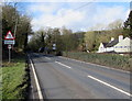
Outdated new road surface sign, Pope's Hill
Viewed on March 1st 2015. The same sign alongside the A4151 Elton Road is in a September 2009 Google Earth Street View. The 50mph speed limit sign has been added since then. The Greyhound Inn http://www.geograph.org.uk/photo/4367590 is on the right.
Image: © Jaggery
Taken: 1 Mar 2015
0.18 miles
10
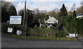
The Greyhound Inn, Pope's Hill
Forest of Dean pub and restaurant on the north side of Elton Road, about midway between Elton and Littledean. There is a white concrete dinosaur in the garden.
Image: © Jaggery
Taken: 1 Mar 2015
0.18 miles