IMAGES TAKEN NEAR TO
The Strood, NEWNHAM, GL14 1JL
Introduction
This page details the photographs taken nearby to The Strood, GL14 1JL by members of the Geograph project.
The Geograph project started in 2005 with the aim of publishing, organising and preserving representative images for every square kilometre of Great Britain, Ireland and the Isle of Man.

There are currently over 7.5m images from over14,400 individuals and you can help contribute to the project by visiting https://www.geograph.org.uk
Image Map
Images are licensed for reuse under creativecommons.org/licenses/by-sa/2.0
Notes
- Clicking on the map will re-center to the selected point.
- The higher the marker number, the further away the image location is from the centre of the postcode.
Image Listing (56 Images Found)
Images are licensed for reuse under creativecommons.org/licenses/by-sa/2.0
Image
Details
Distance
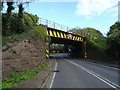
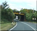
1
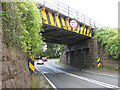
A48, heading for Gloucester
Passing under the railway bridge at Broadoak.
Image: © Pauline E
Taken: 12 Jul 2009
0.02 miles
2
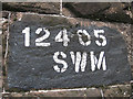
Railway bridge identification, Broadoak
Sprayed onto the local red sandstone.
Image: © Pauline E
Taken: 12 Jul 2009
0.02 miles
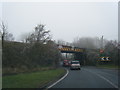
3
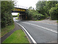
Rail bridge, Broadoak
A48 passing underneath the Gloucester to South Wales line, on its way to Chepstow. Off to the right is a no-through road, The Strood.
Image: © Pauline E
Taken: 12 Jul 2009
0.03 miles
4
Railway bridge near Broadoak
This is a terrible bridge to walk a dog under. The bend is blind and the pavement narrow.
Image: © David Robinson
Taken: 26 Dec 2008
0.03 miles
6
A48 northbound passing under a railway bridge
Image: © Colin Pyle
Taken: 11 Dec 2012
0.04 miles
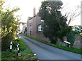
7
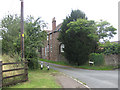
Quay Lane, Broadoak
Access from the A48 to a collection of riverside properties.
Image: © Pauline E
Taken: 12 Jul 2009
0.05 miles
8
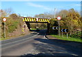
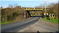
Railway bridge over a tight bend in the A48, Broadoak
Viewed from Quay Lane. The bridge, clearance 14ft 3in (4.3 metres), carries the double track Newport to Gloucester line over the A48. For much of its route from Chepstow, the railway line has been near the west bank of the River Severn. From here to Gloucester, the railway route is further from the river.
Image: © Jaggery
Taken: 6 Nov 2011
0.07 miles
10
Quay Lane, Broadoak
Viewed from the A48 near a railway bridge. http://www.geograph.org.uk/photo/2685861
Shown on some maps as Quarry Lane but the street name sign (on the right) disagrees. Quay Lane leads to Riverside Lane. These two lanes, between the A48 and the River Severn, are the main residential area in the hamlet of Broadoak.
Image: © Jaggery
Taken: 6 Nov 2011
0.07 miles