IMAGES TAKEN NEAR TO
Lansdown Road, GLOUCESTER, GL1 3JF
Introduction
This page details the photographs taken nearby to Lansdown Road, GL1 3JF by members of the Geograph project.
The Geograph project started in 2005 with the aim of publishing, organising and preserving representative images for every square kilometre of Great Britain, Ireland and the Isle of Man.

There are currently over 7.5m images from over14,400 individuals and you can help contribute to the project by visiting https://www.geograph.org.uk
Image Map
Images are licensed for reuse under creativecommons.org/licenses/by-sa/2.0
Notes
- Clicking on the map will re-center to the selected point.
- The higher the marker number, the further away the image location is from the centre of the postcode.
Image Listing (139 Images Found)
Images are licensed for reuse under creativecommons.org/licenses/by-sa/2.0
Image
Details
Distance
1
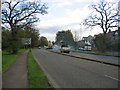
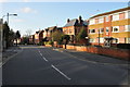
Estcourt Road, Gloucester
This road originally formed a northern bypass for Gloucester but as the city has grown a newer bypass has been built further out. At the time the picture was taken one carriageway was closed for the resurfacing work seen in the distance.
Image: © David Stowell
Taken: 13 Nov 2005
0.07 miles
2
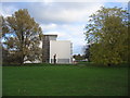
Oxstalls Campus, Gloucester University
This was developed as an academic site in the 1960s as a college of food and domestic science - know locally as the college of grub and scrub!
Image: © David Stowell
Taken: 13 Nov 2005
0.07 miles
3
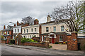
2 - 10 Denmark Road
Late Victorian villas in Denmark Road.
Image: © Ian Capper
Taken: 16 Mar 2019
0.07 miles
4

Gloucester : Holland Court
Holland Court on Denmark Road.
Image: © Lewis Clarke
Taken: 2 Apr 2023
0.07 miles
5
Gloucester : Guild House
A residential house on Denmark Road.
Image: © Lewis Clarke
Taken: 2 Apr 2023
0.08 miles
6
Denmark Road, Gloucester
Denmark Road in Gloucester links London Road with Kingsholm Road
Image: © Philip Halling
Taken: 26 Feb 2011
0.09 miles
7
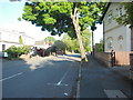
Denmark Rd, Gloucester
Looking towards the Guild House care home down this leafy street. Denmark Road is a long street containing among other things Gloucester High School for Girls, which moved here in 1909. https://www.hsfg.org/page/?title=History+of+the+School&pid=61
Image: © HelenK
Taken: 23 May 2016
0.09 miles
8
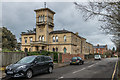
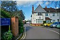
Hillfield House
Large house in Denmark Road, designed by John Giles and built by Charles Estcourt for local timber merchant Charles Walker (timber imports were a major element of Gloucester's trade in the mid 19th Century). Built in 1867 in Italianate style, it replaced an earlier villa on the site dating from 1820. It is described in the Pevsner guide as "the most elaborate Victorian house in Gloucester". For many years it served as local government offices but it has since reverted to residential use. Grade II listed - see www.historicengland.org.uk/listing/the-list/list-entry/1271659.
Image: © Ian Capper
Taken: 16 Mar 2019
0.09 miles
9
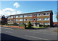
Denmark Court, Denmark Road, Gloucester
An unremarkable but well-preserved example of 1970s flats. Blocks in this vein are found across the country.
Image: © Stephen Richards
Taken: 18 May 2015
0.10 miles
10

Hillfield House
Large house in Denmark Road, designed by John Giles and built by Charles Estcourt for local timber merchant Charles Walker (timber imports were a major element of Gloucester's trade in the mid 19th Century). Built in 1867 in Italianate style, it replaced an earlier villa on the site dating from 1820. It is described in the Pevsner guide as "the most elaborate Victorian house in Gloucester". For many years it served as local government offices but it has since reverted to residential use. Grade II listed - see www.historicengland.org.uk/listing/the-list/list-entry/1271659.
Image: © Ian Capper
Taken: 16 Mar 2019
0.10 miles