IMAGES TAKEN NEAR TO
Hystfield, BERKELEY, GL13 9LN
Introduction
This page details the photographs taken nearby to GL13 9LN by members of the Geograph project.
The Geograph project started in 2005 with the aim of publishing, organising and preserving representative images for every square kilometre of Great Britain, Ireland and the Isle of Man.

There are currently over 7.5m images from over14,400 individuals and you can help contribute to the project by visiting https://www.geograph.org.uk
Image Map
Images are licensed for reuse under creativecommons.org/licenses/by-sa/2.0
Notes
- Clicking on the map will re-center to the selected point.
- The higher the marker number, the further away the image location is from the centre of the postcode.
Image Listing (10 Images Found)
Images are licensed for reuse under creativecommons.org/licenses/by-sa/2.0
Image
Details
Distance
1
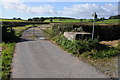
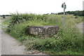
Milk churn stand at the end of the road
The road to Hystfield end here and in the days when milk was collected in churns this is where the dairy would have collected them from with the stand on the right. Both a bridleway and footpath continue from this spot.
Image: © Philip Halling
Taken: 29 Sep 2012
0.04 miles
2
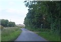
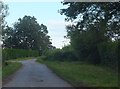
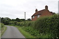
The road through Hystfield
Two small pointers showing public footpaths may be seen, one on either side of the road. In the middle distance is a slightly larger sign showing the route down a side-road to the start of a public bridleway.
Image: © Ruth Riddle
Taken: 24 Jun 2012
0.04 miles
3
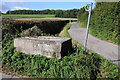
Milk churn stand
Now redundant due to the introduction of bulk tank storage and bulk tanker lorries, milk churn stands were once very common. Even though it was back in the 1970s when they became defunct there are still many to be found in the countryside. This one is at the end of a no through road at Hystfield. A bridleway can be seen in the background and there is a footpath continuing to the south.
Image: © Philip Halling
Taken: 29 Sep 2012
0.04 miles
4
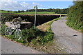
My bike leaning on a milk churn stand
A bicycle is an excellent means of Geographing enabling one the opportunity to explore the lanes and byways.
Image: © Philip Halling
Taken: 29 Sep 2012
0.05 miles
5
Milk Stand top of Hystfield Lane
My father, Alf Beared who worked for Troughton's built that in the 1950s. The original one was wood and it stood inside the gate on the right, at the edge of the lane.
Image: © Alf Beard
Taken: 19 Jun 2016
0.09 miles
6
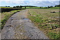
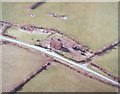
Farm road in a field
A farm road giving access to farmland near Hystfield Farm.
Image: © Philip Halling
Taken: 29 Sep 2012
0.09 miles
7
Lane near Appleridge Farm
Further down this road the route becomes a bridleway named Dog-gate Lane. The direction pointer for the bridleway may just be glimpsed on the leaning pole in the middle distance.
Image: © Ruth Riddle
Taken: 24 Jun 2012
0.09 miles
8
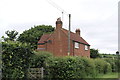
Hystfield Cottage, Hystfield, near Berkeley, Glos
Family home from 1948 - 1993
Image: © Alf Beard
Taken: 19 Jun 2016
0.11 miles
9
Hystfield Cottage, Hystfield, near Berkeley, Glos
Family home from 1948 - 1993
Image: © Alf Beard
Taken: 19 Jun 2016
0.17 miles
10
Hystfield Cottage
This is where I lived for 40 plus years.
Image: © Alf Beard
Taken: 10 Jun 2007
0.17 miles