IMAGES TAKEN NEAR TO
Stone, BERKELEY, GL13 9LJ
Introduction
This page details the photographs taken nearby to GL13 9LJ by members of the Geograph project.
The Geograph project started in 2005 with the aim of publishing, organising and preserving representative images for every square kilometre of Great Britain, Ireland and the Isle of Man.

There are currently over 7.5m images from over14,400 individuals and you can help contribute to the project by visiting https://www.geograph.org.uk
Image Map
Images are licensed for reuse under creativecommons.org/licenses/by-sa/2.0
Notes
- Clicking on the map will re-center to the selected point.
- The higher the marker number, the further away the image location is from the centre of the postcode.
Image Listing (6 Images Found)
Images are licensed for reuse under creativecommons.org/licenses/by-sa/2.0
Image
Details
Distance
1
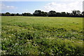
Field near Pedington Farm
Field near Pedington Farm, near Hystfield.
Image: © Philip Halling
Taken: 29 Sep 2012
0.09 miles
2
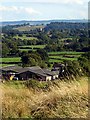
Pedington Farm
View from in Whitcliff Park looking south-east towards Pedington Farm (on the grid-line) and beyond. The tower of the church Image at Stone can be seen.
Image: © Linda Bailey
Taken: 23 Sep 2006
0.12 miles
4
Hystfield Cottage
This is where I lived for 40 plus years.
Image: © Alf Beard
Taken: 10 Jun 2007
0.25 miles
5
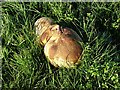
Puff Ball near Appleridge Farm
Giant Puffball, Calvatia gigantea growing in the field. It was about 5 inches by 9 inches in size.
Image: © Linda Bailey
Taken: 23 Sep 2006
0.25 miles
6
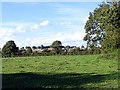
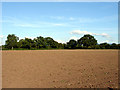
Looking across the fields towards Whitcliff Park
The brown longer grass of Whitcliff Park forms the ridge on the horizon in an otherwise flat landscape. The ridge is Devonian Old Red sandstone.
Image: © Linda Bailey
Taken: 23 Sep 2006
0.25 miles