IMAGES TAKEN NEAR TO
Swanley, Alkington, BERKELEY, GL13 9LH
Introduction
This page details the photographs taken nearby to GL13 9LH by members of the Geograph project.
The Geograph project started in 2005 with the aim of publishing, organising and preserving representative images for every square kilometre of Great Britain, Ireland and the Isle of Man.

There are currently over 7.5m images from over14,400 individuals and you can help contribute to the project by visiting https://www.geograph.org.uk
Image Map
Images are licensed for reuse under creativecommons.org/licenses/by-sa/2.0
Notes
- Clicking on the map will re-center to the selected point.
- The higher the marker number, the further away the image location is from the centre of the postcode.
Image Listing (5 Images Found)
Images are licensed for reuse under creativecommons.org/licenses/by-sa/2.0
Image
Details
Distance
1
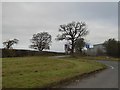
A minor fork off the A38 south of Newport
This side road was originally part of the A38, which has been straightened and widened. The old route has been retained, but the turning has been made into a right-angled junction
Image: © David Smith
Taken: 24 Nov 2016
0.09 miles
2

Guardian Self Store
Self storage facilities close to the A38 at Newport, Glos.
Image: © Thomas Scott
Taken: 3 Sep 2019
0.16 miles
3
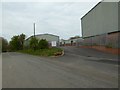
Industrial units
Industrial units on Chapel Hill, the old course of the A38 near Newport.
Image: © Philip Halling
Taken: 19 Apr 2017
0.20 miles
4
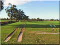
Oakleaze Farm
Waterlogged fields by the A38 at Chapel Hill. The winter wheat should thrive in the sunny and humid conditions prevailing (early November) if it doesn't drown first. The sharp-eyed may be able to pick out the Oakleaze Farm buildings amongst the trees in the centre of the picture.
Image: © Roger May
Taken: 9 Nov 2005
0.22 miles
5
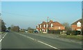
Houses by A38 near Swanley Lane
These red-brick houses are one of two adjacent short terraces that lie to the east of the A38 near the junction with Swanley Lane.
Image: © Ruth Riddle
Taken: 11 Feb 2012
0.24 miles