IMAGES TAKEN NEAR TO
Berkeley Heath, BERKELEY, GL13 9EX
Introduction
This page details the photographs taken nearby to GL13 9EX by members of the Geograph project.
The Geograph project started in 2005 with the aim of publishing, organising and preserving representative images for every square kilometre of Great Britain, Ireland and the Isle of Man.

There are currently over 7.5m images from over14,400 individuals and you can help contribute to the project by visiting https://www.geograph.org.uk
Image Map
Images are licensed for reuse under creativecommons.org/licenses/by-sa/2.0
Notes
- Clicking on the map will re-center to the selected point.
- The higher the marker number, the further away the image location is from the centre of the postcode.
Image Listing (24 Images Found)
Images are licensed for reuse under creativecommons.org/licenses/by-sa/2.0
Image
Details
Distance
1
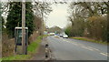
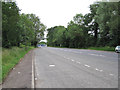
A38, Vale of Berkeley
Heading north-east, approaching the Berkeley road, B4066, on the left.
Image: © Jonathan Billinger
Taken: 1 Mar 2013
0.02 miles
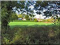
2
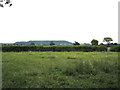
Narrow field east of A38, Berkeley Heath: 2
Looking towards Stinchcombe Hill on the edge of the Cotswolds.
Image: © Robin Stott
Taken: 18 Jun 2010
0.02 miles
3
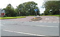
Road from Berkeley Heath to Berkeley
Viewed across the A38 from the edge of Pickwick Farm. The B4066 heads west towards Berkeley, Wanswell, Newtown, Sharpness and Sharpness Docks. Also take the B4066 for Berkeley Castle, the Jenner Museum and Cattle Country Adventure Park.
Image: © Jaggery
Taken: 21 Jul 2012
0.04 miles
4
Entrance to Pickwick Farm, Berkeley Heath
Viewed across the A38 from the corner of the B4066 junction. http://www.geograph.org.uk/photo/3048293
Image: © Jaggery
Taken: 21 Jul 2012
0.06 miles
5
Berkeley Heath
Section of grazing land sandwiched between the A38 and its intersection with the B4066 opposite Pickwick Farm.
Image: © Roger May
Taken: 9 Nov 2005
0.08 miles
6
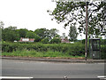
North end of lay-by, A38 Berkeley Heath
Image: © Robin Stott
Taken: 18 Jun 2010
0.08 miles
7
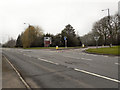
A38/A4066 Junction
Bristol Road (A38) at its junction with the road to Berkeley and Sharpness (B4066).
Image: © David Dixon
Taken: 1 Mar 2012
0.08 miles
9
Twin lay-bys, A38 Berkeley Heath
The distant object in the road is a car transporter turning right towards Berkeley. Another one followed.
Image: © Robin Stott
Taken: 18 Jun 2010
0.11 miles
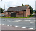
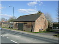
10
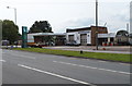
Berkeley Heath Auto Centre
Viewed across the A38. The auto centre includes a BWOC (Bob Wayne's Oil Company) filling station. BWOC was founded in 1982.
Berkeley Heath is a hamlet to the east of the town of Berkeley, Gloucestershire.
Image: © Jaggery
Taken: 21 Jul 2012
0.11 miles