IMAGES TAKEN NEAR TO
Ladybellegate Street, GLOUCESTER, GL1 2HN
Introduction
This page details the photographs taken nearby to Ladybellegate Street, GL1 2HN by members of the Geograph project.
The Geograph project started in 2005 with the aim of publishing, organising and preserving representative images for every square kilometre of Great Britain, Ireland and the Isle of Man.

There are currently over 7.5m images from over14,400 individuals and you can help contribute to the project by visiting https://www.geograph.org.uk
Image Map
Images are licensed for reuse under creativecommons.org/licenses/by-sa/2.0
Notes
- Clicking on the map will re-center to the selected point.
- The higher the marker number, the further away the image location is from the centre of the postcode.
Image Listing (1947 Images Found)
Images are licensed for reuse under creativecommons.org/licenses/by-sa/2.0
Image
Details
Distance
1
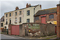
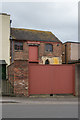
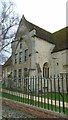
13 - 19 Ladybellegate Street
Buildings in Ladybellegate Street. On the left are nos 13 - 17, an early 19th Century terrace developed out of the west range of the Dominican (Blackfriars) friary, consecrated in 1284. The three buildings in the terrace, nos 13, 15 and 17 are grade II* listed - see www.historicengland.org.uk/listing/the-list/list-entry/1245752, www.historicengland.org.uk/listing/the-list/list-entry/1245753 and www.historicengland.org.uk/listing/the-list/list-entry/1245754 respectively.
On the right is the west front of the south range of the friary, remodelled in the 1540s by the post-dissolution owner Sir Thomas Bell for cloth manufacture, and later further rebuilt for a combination of domestic, commercial and manufacturing usage. It now forms 19 Ladybellegate Street. Part of a lancet window of the original friary can be seen on the right, surrounded by 19th Century brickwork. Grade I listed - see www.historicengland.org.uk/listing/the-list/list-entry/1245992.
The writing on the foreground wall, although now incomplete, would appear to have read "Talbots Bottlers (Gloucester) Ltd, Ladybellegate Street, wholesale beer bottlers". According to https://en.wikipedia.org/wiki/Thomas_Talbot_(bottler), the firm were an occupant of the building for many years.
Image: © Ian Capper
Taken: 16 Mar 2019
0.00 miles
2
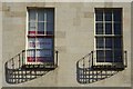
Windows in a Georgian House
Windows with bowed wrought-iron guards on a early 19th century Georgian House on Ladybellgate Street. The house is Grade II* listed.
Image: © Philip Halling
Taken: 13 Sep 2019
0.01 miles
3
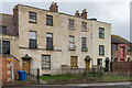
13 - 17 Ladybellegate Street
Early 19th Century terrace developed out of the west range of the Dominican (Blackfriars) friary, consecrated in 1284. The three buildings in the terrace, nos 13, 15 and 17 are grade II* listed - see www.historicengland.org.uk/listing/the-list/list-entry/1245752, www.historicengland.org.uk/listing/the-list/list-entry/1245753 and www.historicengland.org.uk/listing/the-list/list-entry/1245754 respectively.
Image: © Ian Capper
Taken: 16 Mar 2019
0.01 miles
4
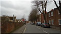
Ladybellegate Street: mid March 2019
Taken on the 2019 Geograph Birthday Meet
Image: © Basher Eyre
Taken: 16 Mar 2019
0.01 miles
5
19 Ladybellegate Street
The west front of the south range of the friary, remodelled in the 1540s by the post-dissolution owner Sir Thomas Bell for cloth manufacture, and later further rebuilt for a combination of domestic, commercial and manufacturing usage.
Part of a lancet window of the original friary can be seen on the right, surrounded by 19th Century brickwork. Grade I listed - see www.historicengland.org.uk/listing/the-list/list-entry/1245992.
Image: © Ian Capper
Taken: 16 Mar 2019
0.01 miles
6
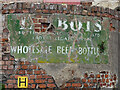
Ghost sign, Ladybellgate Street, Gloucester
It reads:
Talbots / Bottlers (Gloucester) Ltd / Ladybellgate Street / Wholesale Beer Bottlers".
Image: © Stephen Richards
Taken: 17 May 2015
0.01 miles
7
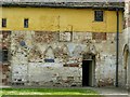
Blackfriars, Gloucester, south range
Remains of the lavatorium at the western end of the south range, mid 13th century trefoiled arcading. The south range is Listed Grade I separately from the other adjoining buildings.
Image: © Alan Murray-Rust
Taken: 15 Apr 2019
0.01 miles
8
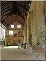
Blackfriars, Gloucester, the church
Looking west from the chancel. Both chancel and nave were much shortened as part of its conversion to a dwelling by Sir Thomas Bell in the mid 16th century, with intermediate floors also being added, as shown by the fireplaces on the end wall. The original fabric of the church dates from the 13th – this includes the roof trusses - and 14th centuries. Listed Grade I.
Image: © Alan Murray-Rust
Taken: 15 Apr 2019
0.01 miles
9
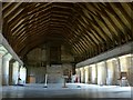
Blackfriars, Gloucester, south range
Scriptorium and library on the upper floor. The roof is the original mid 13th century structure. At the side of the space are a series of carrels with short separating walls providing places for study and writing. The building was converted after the Dissolution to a cloth manufactory, with further later conversions. Listed Grade I.
Blackfriars is an English Heritage property, managed by Gloucester City Council as a function venue.
Image: © Alan Murray-Rust
Taken: 15 Apr 2019
0.02 miles
10
Blackfriars Priory: mid March 2019
Taken on a walk to celebrate Geograph's 14th birthday
Image: © Basher Eyre
Taken: 16 Mar 2019
0.02 miles