IMAGES TAKEN NEAR TO
Commercial Road, GLOUCESTER, GL1 2ED
Introduction
This page details the photographs taken nearby to Commercial Road, GL1 2ED by members of the Geograph project.
The Geograph project started in 2005 with the aim of publishing, organising and preserving representative images for every square kilometre of Great Britain, Ireland and the Isle of Man.

There are currently over 7.5m images from over14,400 individuals and you can help contribute to the project by visiting https://www.geograph.org.uk
Image Map
Images are licensed for reuse under creativecommons.org/licenses/by-sa/2.0
Notes
- Clicking on the map will re-center to the selected point.
- The higher the marker number, the further away the image location is from the centre of the postcode.
Image Listing (1613 Images Found)
Images are licensed for reuse under creativecommons.org/licenses/by-sa/2.0
Image
Details
Distance
1
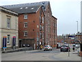
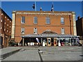
City Flour Mills, Gloucester
Located at the northern end of Gloucester Docks (and on Commercial Road), the City Flour Mills were built in 1850 as a corn mill. Originally, it was a steam operated stone mill but was converted to use steel rollers in 1883. From 1921 the mill was driven electrically. The mill was closed in 1994, and the building has since been turned into apartments.
The mill has a significance in legal history because of a claim for lost profits the mill owners made against a transport company charged with carrying a crank shaft of a steam engine for repairs, which took longer than contractually agreed. In the judgement Hadley vs. Baxendale it was determined that a party in breach of contract was only liable for foreseeable losses which either "arise naturally" from the breach or "would have been in the contemplation of both parties, at the time they made the contract". In this case that meant that the carrier wasn't liable because the contract didn't mention that a delay would have caused the mill owner a loss. I suspect this judgement may well be what lets airlines off the hook when their delays cause people to miss connecting trains.
Image: © Rudi Winter
Taken: 16 Mar 2019
0.00 miles
2
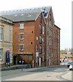
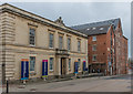
City or Priday Mills, Gloucester
By Gloucester Docks, now converted to apartments. The nearest part of the mills is the oldest, dated 1850, with successive additions beyond. Listed Grade II.
There is a bench mark http://www.geograph.org.uk/photo/6125330 on the near corner of the building.
Image: © Alan Murray-Rust
Taken: 15 Apr 2019
0.00 miles
3
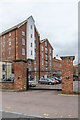
Dock Company Office and Priday Mills
The Dock Company Office was built in 1831 by the Gloucester and Berkeley Canal Company as offices and living accommodation, with later extensions. Subsequently used by the Dock Company. Grade II listed - see www.historicengland.org.uk/listing/the-list/list-entry/1245599.
Beyond are the former City Flour Mills, opened in 1850 originally to mill imported grain but later mainly home-grown grain. It ceased as a mill in 1994 and was converted to residential use in 2004. The building is now called Priday Mills, in commemoration of the firm Priday Metford and Co Ltd which had operated the mill for much of its life. Also grade II listed - see www.historicengland.org.uk/listing/the-list/list-entry/1245598.
Image: © Ian Capper
Taken: 16 Mar 2019
0.01 miles
4
Priday Mills
The former City Flour Mills, opened in 1850 originally to mill imported grain but later mainly home-grown grain. It ceased as a mill in 1994 and was converted to residential use in 2004. The building is now called Priday Mills, in commemoration of the firm Priday Metford and Co Ltd which had operated the mill for much of its life. Grade II listed - see www.historicengland.org.uk/listing/the-list/list-entry/1245598.
Image: © Ian Capper
Taken: 16 Mar 2019
0.01 miles
5
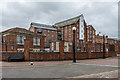
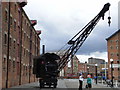
Soldiers of Gloucestershire Museum
Soldiers of Gloucestershire Museum overlooking the Victoria Dock in Gloucester Docks.
Image: © Philip Halling
Taken: 23 Feb 2019
0.01 miles
7

Bench mark, City Mills, Gloucester
See http://www.geograph.org.uk/photo/6125332 for location
Image: © Alan Murray-Rust
Taken: 15 Apr 2019
0.01 miles
8

Ordnance Survey Cut Mark
This OS cut mark can be found on the east angle of the City Flour Mills building. It marks a point 14.72m above mean sea level.
Image: © Adrian Dust
Taken: 9 Jul 2022
0.01 miles
9
Custom House and Priday Mills
Custom House, on the left is a former customs office completed in 1845 in anticipation of a growth in foreign trade through Gloucester docks. The architect was Sydney Smirke. Although foreign trade declined, it continued in use as administrative offices until the late 1970s. It then became the headquarters of the Gloucestershire Regiment, including housing a museum commemorating the regiment, previously in Westgate Street. It subsequently underwent some remodelling, reopening in 1990 and then had further changes made, completed in 2014. Originally known as the Regiments of Gloucestershire Museum, it is now called the Soldiers of Gloucestershire Museum. Grade II listed - see www.historicengland.org.uk/listing/the-list/list-entry/1271653.
Beyond are the former City Flour Mills, opened in 1850 originally to mill imported grain but later mainly home-grown grain. It ceased as a mill in 1994 and was converted to residential use in 2004. The building is now called Priday Mills, in commemoration of the firm Priday Metford and Co Ltd which had operated the mill for much of its life. Also grade II listed - see www.historicengland.org.uk/listing/the-list/list-entry/1245598.
Image: © Ian Capper
Taken: 16 Mar 2019
0.02 miles
10
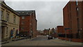
Looking west-northwest in Commercial Road
Taken on a walk to celebrate Geograph's 14th birthday
Image: © Basher Eyre
Taken: 16 Mar 2019
0.02 miles