IMAGES TAKEN NEAR TO
The Orchard, WOTTON-UNDER-EDGE, GL12 8UX
Introduction
This page details the photographs taken nearby to The Orchard, GL12 8UX by members of the Geograph project.
The Geograph project started in 2005 with the aim of publishing, organising and preserving representative images for every square kilometre of Great Britain, Ireland and the Isle of Man.

There are currently over 7.5m images from over14,400 individuals and you can help contribute to the project by visiting https://www.geograph.org.uk
Image Map
Images are licensed for reuse under creativecommons.org/licenses/by-sa/2.0
Notes
- Clicking on the map will re-center to the selected point.
- The higher the marker number, the further away the image location is from the centre of the postcode.
Image Listing (79 Images Found)
Images are licensed for reuse under creativecommons.org/licenses/by-sa/2.0
Image
Details
Distance
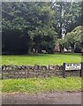
1
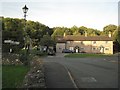
Cottages near the church, Tytherington
Church Cottage, left, and Smithy Cottage, right, on the corner of Baden Hill Road.
Image: © Robin Stott
Taken: 20 Sep 2010
0.03 miles
2
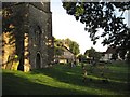
Tytherington churchyard
Church Cottage, centre. The Swan pub (free house) on the right.
Image: © Robin Stott
Taken: 20 Sep 2010
0.03 miles
3
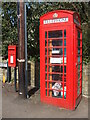
Tytherington swap box
The old phone box now has a selection of interests, mainly books but also including other items.
Image: © Neil Owen
Taken: 15 Apr 2021
0.04 miles
4
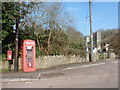
Tytherington: postbox № GL12 189 and phone
The village postbox stands alongside a red telephone box in West Street. The parish church is in the background, across the sports field.
Image: © Chris Downer
Taken: 18 Feb 2013
0.05 miles
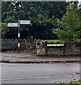
5
New Road name sign, Tytherington, South Gloucestershire
The sign at the Stowell Hill Road junction shows that New Road leads to Tytherington Hill.
Image: © Jaggery
Taken: 24 Sep 2023
0.05 miles
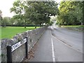
6
Distances from Tytherington, South Gloucestershire
Left for Cromhall (3 miles) and Iron Acton (4).
Right for Grovesend (1) and Thornbury (1½).
A Stowell Hill Road name sign is on the right.
Image: © Jaggery
Taken: 24 Sep 2023
0.06 miles

8
Stowell Hill Road, Tytherington: 2
On the left. a recreation ground and play area; on the right, the churchyard.
Image: © Robin Stott
Taken: 20 Sep 2010
0.06 miles
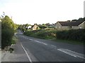
10
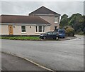
Bungalow in Tytherington, South Gloucestershire
Derived from a Hindi word meaning "in the style of Bengal", bungalow was
originally used in English for a lightly-built one-storey house with a veranda.
In current UK usage it is a convenient word for any single storey dwelling.
Image: © Jaggery
Taken: 24 Sep 2023
0.06 miles