IMAGES TAKEN NEAR TO
Underhill Road, WOTTON-UNDER-EDGE, GL12 8TQ
Introduction
This page details the photographs taken nearby to Underhill Road, GL12 8TQ by members of the Geograph project.
The Geograph project started in 2005 with the aim of publishing, organising and preserving representative images for every square kilometre of Great Britain, Ireland and the Isle of Man.

There are currently over 7.5m images from over14,400 individuals and you can help contribute to the project by visiting https://www.geograph.org.uk
Image Map
Images are licensed for reuse under creativecommons.org/licenses/by-sa/2.0
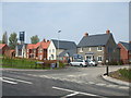
Notes
- Clicking on the map will re-center to the selected point.
- The higher the marker number, the further away the image location is from the centre of the postcode.
Image Listing (112 Images Found)
Images are licensed for reuse under creativecommons.org/licenses/by-sa/2.0
Image
Details
Distance
1
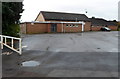
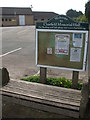
Charfield Memorial Hall, Charfield
Set back 40 metres from the south side of Wotton Road.
Image: © Jaggery
Taken: 28 Oct 2012
0.11 miles
2
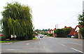
Wotton Road, Charfield, Gloucestershire 2014
Image: © Ray Bird
Taken: 11 Sep 2014
0.12 miles
3
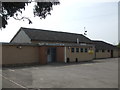
Charfield village hall
This modern community facility has a bit of a past: once there was a small quarry site here but in 1915 an opportunity came about to provide for some local needs. The land seen here was sold and later resold in 1922 to the Charfield and District Red Triangle Club, which started with a small hall (the Richardson Hut). The adjoining land (now the recreation and playing field) came under the control of the local parish council in 1948, and the two sites were held under two titles. However, by 1956 the Red Triangle Club were facing severe problems and finally handed over the hall to the local parish council. Following a legally binding agreement, the combined hall and fields site was given over as the responsibility for the council in full.
Image: © Neil Owen
Taken: 18 Apr 2019
0.12 miles
4
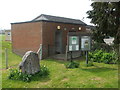
Welcome to Charfield!
A particularly welcome sight if you are needy. The conveniences date from 1975, the stone was provided by the villagers to mark the Queen's Diamond Jubilee in June 2012.
Image: © Neil Owen
Taken: 18 Apr 2019
0.12 miles
5
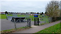
Charfield playing field
Children's play area viewed from the Little Bristol Lane.
Image: © Jonathan Billinger
Taken: 16 Mar 2012
0.12 miles
6
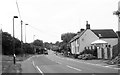
Wotton Road, Charfield, Gloucestershire 2014
Image: © Ray Bird
Taken: 11 Sep 2014
0.12 miles
7
A seat for the visitors
A curious style of seating for anyone passing by Charfield's hall.
Image: © Neil Owen
Taken: 18 Apr 2019
0.13 miles
8
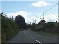
Bend in the road and traffic island in Charfield
There are fields on one side of the road, and houses on the other.
Image: © David Smith
Taken: 28 Jul 2012
0.13 miles
9
St James Mews
Charfield is growing - this new development is offering 3- and 4-bedroom homes, along with some affordable housing. Prices start around a third of a million.
Image: © Neil Owen
Taken: 18 Apr 2019
0.13 miles
10
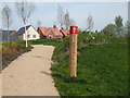
Playpark this way
The new housing development of St James Mews in Charfield features a small strip of green in front of it that includes some exercise kit.
Image: © Neil Owen
Taken: 18 Apr 2019
0.13 miles