IMAGES TAKEN NEAR TO
May Grove, WOTTON-UNDER-EDGE, GL12 8SX
Introduction
This page details the photographs taken nearby to May Grove, GL12 8SX by members of the Geograph project.
The Geograph project started in 2005 with the aim of publishing, organising and preserving representative images for every square kilometre of Great Britain, Ireland and the Isle of Man.

There are currently over 7.5m images from over14,400 individuals and you can help contribute to the project by visiting https://www.geograph.org.uk
Image Map
Images are licensed for reuse under creativecommons.org/licenses/by-sa/2.0
Notes
- Clicking on the map will re-center to the selected point.
- The higher the marker number, the further away the image location is from the centre of the postcode.
Image Listing (93 Images Found)
Images are licensed for reuse under creativecommons.org/licenses/by-sa/2.0
Image
Details
Distance
1
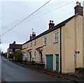
Station Road houses, Charfield
Looking north towards Wotton Road. There is a footpath sign on the right.
Image: © Jaggery
Taken: 28 Oct 2012
0.04 miles
2
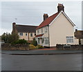
Houses on the corner of Station Road and Horsford Road, Charfield
The street name sign shows Horsford Road.
Image: © Jaggery
Taken: 28 Oct 2012
0.06 miles
3
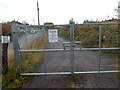
Gate across a railway access lane in Charfield
Viewed from Station Road. There is an Amey Colas warning notice on the locked gate.
Image: © Jaggery
Taken: 28 Oct 2012
0.06 miles
4
A clue in Station Road
Some strangely railway-like steel on Station Road.
Image: © Neil Owen
Taken: 18 Apr 2019
0.06 miles
5
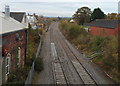
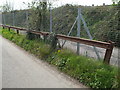
Railway passes the site of the former Charfield station
Viewed from this http://www.geograph.org.uk/photo/3728506 footbridge. The line from Gloucester to Bristol passes the site of Charfield station. Visible on the left in the middle distance, a platform http://www.geograph.org.uk/photo/3726431 and the main station buildings remain. Passenger services were withdrawn from Charfield in January 1965. Goods services ended later that year.
Image: © Jaggery
Taken: 28 Oct 2012
0.06 miles
6
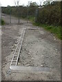
Set into the ground
An outline of some ironmongery along Station Road - possibly connected in the past with the adjoining railway?
Image: © Neil Owen
Taken: 18 Apr 2019
0.06 miles
7

Unusual barrier alongside Station Road, Charfield
The barrier is made up of horizontal sections of railway track bolted together, supported by shorter sections of track. The barrier is alongside a wire fence at the edge of an access lane to the Bristol to Gloucester railway line.
Image: © Jaggery
Taken: 28 Oct 2012
0.06 miles
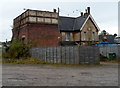
8
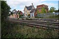
Former Charfield Station
Former Charfield Station on the Gloucester to Bristol railway.
Image: © Philip Halling
Taken: 26 Sep 2015
0.07 miles
9
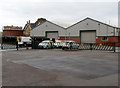
Old station yard in Charfield
Viewed from Station Road across the yard now occupied by M J Fews Land Rover dealership towards a disused railway water tower. http://www.geograph.org.uk/photo/3726156
Image: © Jaggery
Taken: 28 Oct 2012
0.07 miles
10
Former railway water tower in Charfield
Viewed from Station Road. Much of the former Charfield railway station survives, alongside the main line which is still in use (the Bristol to Gloucester line). The main station building and the station master's house are in residential use. Passenger services were withdrawn from Charfield in January 1965. Goods services ended later that year.
Image: © Jaggery
Taken: 28 Oct 2012
0.07 miles