IMAGES TAKEN NEAR TO
Abbey Street, WOTTON-UNDER-EDGE, GL12 8RD
Introduction
This page details the photographs taken nearby to Abbey Street, GL12 8RD by members of the Geograph project.
The Geograph project started in 2005 with the aim of publishing, organising and preserving representative images for every square kilometre of Great Britain, Ireland and the Isle of Man.

There are currently over 7.5m images from over14,400 individuals and you can help contribute to the project by visiting https://www.geograph.org.uk
Image Map
Images are licensed for reuse under creativecommons.org/licenses/by-sa/2.0
Notes
- Clicking on the map will re-center to the selected point.
- The higher the marker number, the further away the image location is from the centre of the postcode.
Image Listing (71 Images Found)
Images are licensed for reuse under creativecommons.org/licenses/by-sa/2.0
Image
Details
Distance
1
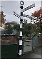
Direction Sign ? Signpost
Located on the pavement on the east side of the junction of the B4060 Old Rectory Road, B4062 Charfield Road and B4060 Wotton Road, beside a brick wall, and next to the war memorial shelter in Kingswood parish. 3 replacement arms and annulus finial. See also http://www.geograph.org.uk/photo/5843614 and http://www.geograph.org.uk/photo/288231.
Milestone Society National ID: GL_ST7492
Image: © S Kosciow
Taken: 20 Apr 2019
0.01 miles
2
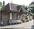
War Memorial Shelter and Fingerpost, Kingswood
The memorial commemorates the 13 parishioners who died in the First World War, the 8 in the Second World War and one in Korea.
Image: © James Purkiss
Taken: 6 Sep 2005
0.01 miles
3
War Memorial Plaque, Kingswood, nr Wotton Under Edge, Gloucestershire 2014
Image: © Ray Bird
Taken: 8 Sep 2014
0.02 miles
4
Bus Shelter & Signpost, Wotton Rd / Charfield Rd Junction, Kingswood, nr Wotton Under Edge, Gloucestershire 2014
Image: © Ray Bird
Taken: 8 Sep 2014
0.02 miles
5

Primary school in Kingswood
Primary school on Abbey Street in Kingswood.
Image: © Philip Halling
Taken: 19 Apr 2017
0.02 miles
6

Kingswood war memorial
The names of the fallen in World War II on Kingswood war memorial.
Image: © Philip Halling
Taken: 19 Apr 2017
0.02 miles
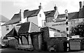
7

War memorial in Kingswood
This war memorial in Kingswood has the appearance of a bus shelter.
Image: © Philip Halling
Taken: 19 Apr 2017
0.02 miles
8

Kingswood war memorial
The names of the fallen in World War II on Kingswood war memorial.
Image: © Philip Halling
Taken: 19 Apr 2017
0.02 miles
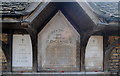
9

Names on Kingswood war memorial
The names of the fallen in World War I, plus one from the Korean War in 1953, on Kingswood war memorial.
Image: © Philip Halling
Taken: 19 Apr 2017
0.02 miles
10
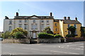
The Old Rectory, Kingswood, nr Wotton Under Edge, Gloucestershire 2014
Image: © Ray Bird
Taken: 8 Sep 2014
0.03 miles