IMAGES TAKEN NEAR TO
Walnut Field, WOTTON-UNDER-EDGE, GL12 8QS
Introduction
This page details the photographs taken nearby to Walnut Field, GL12 8QS by members of the Geograph project.
The Geograph project started in 2005 with the aim of publishing, organising and preserving representative images for every square kilometre of Great Britain, Ireland and the Isle of Man.

There are currently over 7.5m images from over14,400 individuals and you can help contribute to the project by visiting https://www.geograph.org.uk
Image Map
Images are licensed for reuse under creativecommons.org/licenses/by-sa/2.0
Notes
- Clicking on the map will re-center to the selected point.
- The higher the marker number, the further away the image location is from the centre of the postcode.
Image Listing (81 Images Found)
Images are licensed for reuse under creativecommons.org/licenses/by-sa/2.0
Image
Details
Distance
1

Tytherington Railway Station
The station has seen no passengers for over 20 years but appears to be in remarkably good condition. An occasional goods train will still pass by on its way to Thornbury but not for much longer - the service will be withdrawn later in the year. However, that closure would only be temporary because stone traffic to Tytherington Quarry, about ½ mile behind me, would resume in 1972. At some stage the station building has been demolished - probably shortly after the 1966 closure.
Image: © Martin Tester
Taken: Unknown
0.04 miles
2
Railway crosses the road at Tytherington
Image: © Sarah Charlesworth
Taken: 7 Apr 2011
0.05 miles
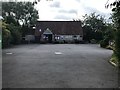
3
Tytherington village shop
The Lottery-funded building stands where the old church hall did. The latter was a twentieth century structure that was an old army hut previously used by Polish soldiers at Babdown. It was demolished in 1996 to make way for the new post office and stores. Outside are a couple of memorials (a bench and a floral display) to cherished villagers.
Image: © Neil Owen
Taken: 15 Apr 2021
0.06 miles
5
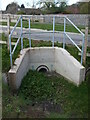
Draining Duck Street
A new culvert allows the issues to flow away from the centre of the village. This part of the surrounds has been developed as a housing area in recent years as well as new farming.
Image: © Neil Owen
Taken: 15 Apr 2021
0.06 miles
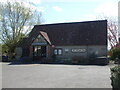
6
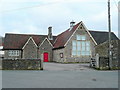
Tytherington village hall
Presumably this was previously the primary school.
Viewed from Itchington Road.
See; http://www.tytherington.com/
Image: © Jonathan Billinger
Taken: 21 Jan 2011
0.07 miles
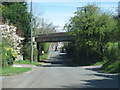
7
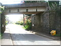
Railway bridge over Itchington Road
The old quarry line passes over the road in Tytherington. On the stonework near the grit bin is a benchmark - see Image
Image: © Neil Owen
Taken: 15 Apr 2021
0.07 miles
8
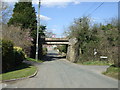
Railway bridge over Itchington Road, Tytherington
Image: © JThomas
Taken: 2 Apr 2013
0.07 miles
9
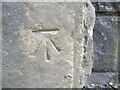
Benchmark on Itchington Road railway bridge
Dating from the mid twentieth century, this benchmark is listed in the Benchmark Database: https://www.bench-marks.org.uk/bm91186 . See Image] for a wider view.
Image: © Neil Owen
Taken: 15 Apr 2021
0.07 miles
10
The Nurseries name sign on a Tytherington corner, South Gloucestershire
Near the Village Hall and Village Shop & Post Office.
Image: © Jaggery
Taken: 24 Sep 2023
0.07 miles