IMAGES TAKEN NEAR TO
Itchington Road, WOTTON-UNDER-EDGE, GL12 8QG
Introduction
This page details the photographs taken nearby to Itchington Road, GL12 8QG by members of the Geograph project.
The Geograph project started in 2005 with the aim of publishing, organising and preserving representative images for every square kilometre of Great Britain, Ireland and the Isle of Man.

There are currently over 7.5m images from over14,400 individuals and you can help contribute to the project by visiting https://www.geograph.org.uk
Image Map
Images are licensed for reuse under creativecommons.org/licenses/by-sa/2.0
Notes
- Clicking on the map will re-center to the selected point.
- The higher the marker number, the further away the image location is from the centre of the postcode.
Image Listing (7 Images Found)
Images are licensed for reuse under creativecommons.org/licenses/by-sa/2.0
Image
Details
Distance
4
Itchington Road, Tytherington
A parallel bridleway leads straight on away from the camera.
Image: © Jonathan Billinger
Taken: 21 Jan 2011
0.05 miles
5
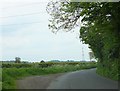
Pylon by Itchington Road
This area is crossed by many powerlines leading from a large substation nearby, and this picture was taken virtually underneath where one set cross Itchington Road, looking towards a pylon further along the road that carries another set.
Image: © Ruth Riddle
Taken: 18 May 2012
0.11 miles
6
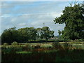
Overgrown Meadow
Looking West near middle of square
Image: © Chris Shaw
Taken: Unknown
0.18 miles
7
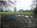
Wet winter pasture
Low-lying pasture land between Itchington and Tytherington.
Image: © Jonathan Billinger
Taken: 21 Jan 2011
0.21 miles