IMAGES TAKEN NEAR TO
Woodlands Road, WOTTON-UNDER-EDGE, GL12 8LU
Introduction
This page details the photographs taken nearby to Woodlands Road, GL12 8LU by members of the Geograph project.
The Geograph project started in 2005 with the aim of publishing, organising and preserving representative images for every square kilometre of Great Britain, Ireland and the Isle of Man.

There are currently over 7.5m images from over14,400 individuals and you can help contribute to the project by visiting https://www.geograph.org.uk
Image Map
Images are licensed for reuse under creativecommons.org/licenses/by-sa/2.0
Notes
- Clicking on the map will re-center to the selected point.
- The higher the marker number, the further away the image location is from the centre of the postcode.
Image Listing (18 Images Found)
Images are licensed for reuse under creativecommons.org/licenses/by-sa/2.0
Image
Details
Distance
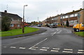
1
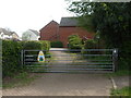
A gated road
No obvious reason for it but there is a gate that separates two suburban roads (Woodlands Road and Hawthorn Close). Perhaps it is to prevent heavy traffic using what is a small bridge over a stream. It is locked for security. The egg is presumably for an Easter event in the area.
Image: © Neil Owen
Taken: 18 Apr 2019
0.03 miles
3
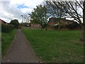
A stream at the end of the housing
Charfield has a number of little streams that run down from the escarpment to the west and gather in the Little Avon River. This one is partly culverted at the outskirts of the modern housing estate.
Image: © Neil Owen
Taken: 18 Apr 2019
0.08 miles
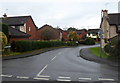
4
Manor Lane, Charfield
Viewed from Charfield Green. On the left, low metal barriers prevent vehicles parking on, or otherwise misusing, the green.
Image: © Jaggery
Taken: 28 Oct 2012
0.17 miles
5
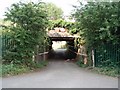
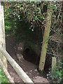
Railway bridge and tunnel
This tunnel links Little Bristol road with Station road under the railway just to the south of Charfield.
Image: © Sharon Loxton
Taken: 3 Jul 2006
0.18 miles
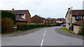
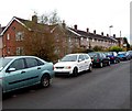
6
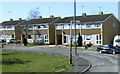
Woodlands Road, Charfield
Viewed across Little Bristol Lane. Woodlands Road is a long cul-de-sac of about 200 houses.
Image: © Jaggery
Taken: 28 Oct 2012
0.20 miles
7
Woodlands Road
Access to a large housing estate off Little Bristol Lane, Charfield.
Image: © Jonathan Billinger
Taken: 16 Mar 2012
0.21 miles
8
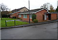
Little Bristol Close bungalows, Charfield
Viewed from Little Bristol Lane.
Image: © Jaggery
Taken: 28 Oct 2012
0.22 miles
9
Charfield Green houses, Charfield
The road is named Charfield Green ahead, Little Bristol Lane behind the camera.
Image: © Jaggery
Taken: 28 Oct 2012
0.22 miles