IMAGES TAKEN NEAR TO
Little Bristol Lane, WOTTON-UNDER-EDGE, GL12 8LL
Introduction
This page details the photographs taken nearby to Little Bristol Lane, GL12 8LL by members of the Geograph project.
The Geograph project started in 2005 with the aim of publishing, organising and preserving representative images for every square kilometre of Great Britain, Ireland and the Isle of Man.

There are currently over 7.5m images from over14,400 individuals and you can help contribute to the project by visiting https://www.geograph.org.uk
Image Map
Images are licensed for reuse under creativecommons.org/licenses/by-sa/2.0
Notes
- Clicking on the map will re-center to the selected point.
- The higher the marker number, the further away the image location is from the centre of the postcode.
Image Listing (4 Images Found)
Images are licensed for reuse under creativecommons.org/licenses/by-sa/2.0
Image
Details
Distance
3
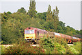
The Gloucester to Bristol line
60 093 heads south with a heavy load of 28 tankers.
Image: © Stuart Wilding
Taken: 25 Sep 2008
0.17 miles
4
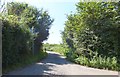
No through road to Southend Farm
The view from the junction with Little Bristol Lane and Devil's Lane. There are in fact two road signs indicating that this lane is a dead end, but one of them is almost totally obscured by foliage!
Image: © Ruth Riddle
Taken: 10 Aug 2012
0.23 miles