IMAGES TAKEN NEAR TO
Chase Lane, WOTTON-UNDER-EDGE, GL12 8JY
Introduction
This page details the photographs taken nearby to Chase Lane, GL12 8JY by members of the Geograph project.
The Geograph project started in 2005 with the aim of publishing, organising and preserving representative images for every square kilometre of Great Britain, Ireland and the Isle of Man.

There are currently over 7.5m images from over14,400 individuals and you can help contribute to the project by visiting https://www.geograph.org.uk
Image Map
Images are licensed for reuse under creativecommons.org/licenses/by-sa/2.0
Notes
- Clicking on the map will re-center to the selected point.
- The higher the marker number, the further away the image location is from the centre of the postcode.
Image Listing (15 Images Found)
Images are licensed for reuse under creativecommons.org/licenses/by-sa/2.0
Image
Details
Distance
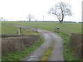
1
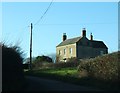
Chase House Farmhouse
The front facade of this building lies right along a gridline, with the building stretching back into the square in question, meaning that to get a meaningful shot of the whole building in its geographical context with relation to the road I had to move a short distance into the next square to the south - very awkward, but as it is a distinctive building in a very prominent position, and quite a landmark, particularly when silhouetted against the sky when approached from the southeast up the hill, it seemed worth the effort to document it.
Image: © Ruth Riddle
Taken: 25 Feb 2012
0.00 miles
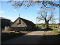
2
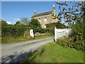
Chasehouse Farm
Chasehouse farmhouse is actually just across the grid boundary in the adjoining square.
Image: © Philip Halling
Taken: 5 Oct 2016
0.02 miles
3
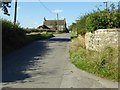
House on Chase Lane
House on Chase Lane to the east of Wickwar.
Image: © Philip Halling
Taken: 5 Oct 2016
0.03 miles
4
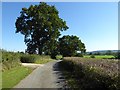
Oak trees beside a no through road
Oak trees beside a no through road which gives access to Mounteney's Farm near Wickwar.
Image: © Philip Halling
Taken: 5 Oct 2016
0.09 miles
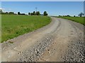
6
Chase Lane Farm
And the lane to Wickwar. As you near the village, about 850 metres ahead, you really don't want to meet anything coming the other way! The lane is narrow and twisty, with high banks and almost nowhere to pass.
Image: © David Purchase
Taken: 6 Nov 2016
0.17 miles
7
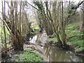
Saltmoors Ditch
A stream draining from Inglestone Common.
Image: © Jonathan Billinger
Taken: 30 Mar 2007
0.18 miles
8
Drive to Mounteney's Farm
Farm drive to Mounteney's Farm near Wickwar.
Image: © Philip Halling
Taken: 5 Oct 2016
0.19 miles
9
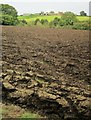
Field by Saltmoors Ditch
Looking from footpath LHA/37 across a ploughed field and across the valley of Saltmoors Ditch to Chaselane Farm. The wood by the stream is Sturt Brake.
Image: © Derek Harper
Taken: 27 Sep 2014
0.20 miles
10
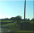
Looking west along Chase Lane
From this point on Chase Lane a public footpath heads north, running for a short distance along the eastern side of a small walled agricultural yard. The tower of Wickwar Church can be seen on the horizon, a little over a kilometre away.
Image: © Ruth Riddle
Taken: 25 Feb 2012
0.20 miles