IMAGES TAKEN NEAR TO
Farm Lees, WOTTON-UNDER-EDGE, GL12 8JA
Introduction
This page details the photographs taken nearby to Farm Lees, GL12 8JA by members of the Geograph project.
The Geograph project started in 2005 with the aim of publishing, organising and preserving representative images for every square kilometre of Great Britain, Ireland and the Isle of Man.

There are currently over 7.5m images from over14,400 individuals and you can help contribute to the project by visiting https://www.geograph.org.uk
Image Map
Images are licensed for reuse under creativecommons.org/licenses/by-sa/2.0
Notes
- Clicking on the map will re-center to the selected point.
- The higher the marker number, the further away the image location is from the centre of the postcode.
Image Listing (52 Images Found)
Images are licensed for reuse under creativecommons.org/licenses/by-sa/2.0
Image
Details
Distance
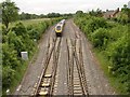
1
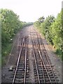
Railway
This line heads south to Yate and Bristol Parkway, and north to Cam and Dursley.
Image: © Sharon Loxton
Taken: 3 Jul 2006
0.14 miles
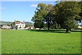
2
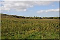
Field beside the Gloucester to Bristol Railway
Field beside the Gloucester to Bristol Railway near Charfield. The railway embankment is on the left.
Image: © Philip Halling
Taken: 26 Sep 2015
0.14 miles
3
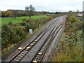
2 tracks into 4, Charfield
Viewed from the Wotton Road bridge looking along the Bristol to Gloucester main line.
Image: © Jaggery
Taken: 28 Oct 2012
0.18 miles
4
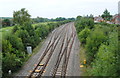
Railway, Charfield, Gloucestershire 2014
This was the site of the Charfield Train Crash on October 13th 1928.
Image: © Ray Bird
Taken: 11 Sep 2014
0.20 miles
5
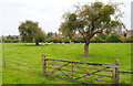
Sheep in old Orchard, Charfield, Gloucestershire 2014
Image: © Ray Bird
Taken: 11 Sep 2014
0.20 miles
6
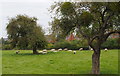
Sheep in old Orchard, Charfield, Gloucestershire 2014
Image: © Ray Bird
Taken: 11 Sep 2014
0.21 miles
9
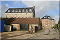
Charfield Mills
There were three mills in this complex but the third is out of sight and has been reduced from 5 to two floors in conversion to housing. The furthest is a water powered mill of c1812 and later adapted for water and steam power. The nearer block is an 1825 steam mill with integral engine house and lean to boiler house. The nearer low buildings conceal an attached north light shed on an earlier tenterfield. The front of a Lancashire boiler has been preserved and can be seen from the road. The further mill has been converted to housing and the nearer is used by engineering companies.
Image: © Chris Allen
Taken: 27 Oct 2013
0.22 miles
10
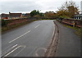
Across a railway bridge, Charfield
The B4058 Wotton Road crosses above the Bristol to Gloucester railway. Although there is a pavement here, there is also a black and white footbridge, http://www.geograph.org.uk/photo/3728501 on the right.
Image: © Jaggery
Taken: 28 Oct 2012
0.22 miles