IMAGES TAKEN NEAR TO
Woodland Road, WOTTON-UNDER-EDGE, GL12 8HT
Introduction
This page details the photographs taken nearby to Woodland Road, GL12 8HT by members of the Geograph project.
The Geograph project started in 2005 with the aim of publishing, organising and preserving representative images for every square kilometre of Great Britain, Ireland and the Isle of Man.

There are currently over 7.5m images from over14,400 individuals and you can help contribute to the project by visiting https://www.geograph.org.uk
Image Map
Images are licensed for reuse under creativecommons.org/licenses/by-sa/2.0
Notes
- Clicking on the map will re-center to the selected point.
- The higher the marker number, the further away the image location is from the centre of the postcode.
Image Listing (5 Images Found)
Images are licensed for reuse under creativecommons.org/licenses/by-sa/2.0
Image
Details
Distance
1
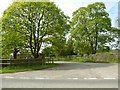
Entrance to Woodland Road
Entrance to Woodland Road and housing at Leyhill.
Image: © Philip Halling
Taken: 19 Apr 2017
0.10 miles
2
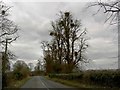
Trees near Leyhill prison
Are the clumps in the trees mistletoe?
Image: © Steve Fareham
Taken: 6 Mar 2008
0.12 miles
4
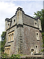
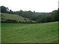
Lake Lodge
The Tortworth estate comprises a large area of land that now encloses a fishing lake. This lodge was built in the late 1800s.
Image: © Neil Owen
Taken: 8 Aug 2019
0.23 miles