IMAGES TAKEN NEAR TO
Charfield, WOTTON-UNDER-EDGE, GL12 8HE
Introduction
This page details the photographs taken nearby to GL12 8HE by members of the Geograph project.
The Geograph project started in 2005 with the aim of publishing, organising and preserving representative images for every square kilometre of Great Britain, Ireland and the Isle of Man.

There are currently over 7.5m images from over14,400 individuals and you can help contribute to the project by visiting https://www.geograph.org.uk
Image Map
Images are licensed for reuse under creativecommons.org/licenses/by-sa/2.0
Notes
- Clicking on the map will re-center to the selected point.
- The higher the marker number, the further away the image location is from the centre of the postcode.
Image Listing (4 Images Found)
Images are licensed for reuse under creativecommons.org/licenses/by-sa/2.0
Image
Details
Distance
1
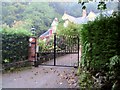
Keeper's Lodge at Damery
This house is well concealed behind neat hedges. It borders on Michael's Wood, a private estate, from which the M5 motorway services derives its name.
Image: © Roger May
Taken: 19 Oct 2005
0.14 miles
2
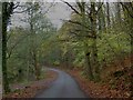
Damery Lane alongside the Little Avon river
It's hard to believe the M5 motorway is very near this tranquil scene. The woodland is Michael Wood which gives its name to the services on the M5.
Image: © Steve Fareham
Taken: 11 Nov 2009
0.17 miles
3
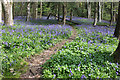
Michael Wood near Damery Lane
Bluebell wood.
Image: © Charles Drown
Taken: 21 Apr 2014
0.18 miles
4
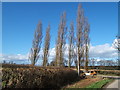
Poplars and a Peugeot
This small stand of poplars lining the lane is not enhanced by the burnt out car which appears to have been there a while. Obviously once a very hot hatch!
Image: © David Collins
Taken: 1 Mar 2007
0.21 miles