IMAGES TAKEN NEAR TO
Selman Drive, GL12 8FJ
Introduction
This page details the photographs taken nearby to Selman Drive, GL12 8FJ by members of the Geograph project.
The Geograph project started in 2005 with the aim of publishing, organising and preserving representative images for every square kilometre of Great Britain, Ireland and the Isle of Man.

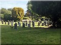
There are currently over 7.5m images from over14,400 individuals and you can help contribute to the project by visiting https://www.geograph.org.uk
Image Map
Images are licensed for reuse under creativecommons.org/licenses/by-sa/2.0
Notes
- Clicking on the map will re-center to the selected point.
- The higher the marker number, the further away the image location is from the centre of the postcode.
Image Listing (71 Images Found)
Images are licensed for reuse under creativecommons.org/licenses/by-sa/2.0
Image
Details
Distance
1
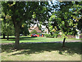
Orchard View, Sundayshill Lane, Falfield
A row of houses is set back from the lane by this pleasant open space.
Image: © Robin Stott
Taken: 16 Jul 2010
0.09 miles
2
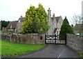
The Old Vicarage, Falfield
It's New Year's Day, but this view of The Old Vicarage is partially blocked by two evergreens. Next door on the left is Falfield Village Hall. http://www.geograph.org.uk/photo/2749686
Image: © Jaggery
Taken: 1 Jan 2012
0.09 miles
3
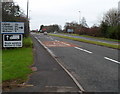
Falfield : route ahead for van drivers to avoid Wotton-under-Edge
I don't know what hazards await van drivers in Wotton-under-Edge, but they can be avoided by using the route indicated on the sign on the A38 in Falfield.
Image: © Jaggery
Taken: 1 Jan 2012
0.09 miles
4
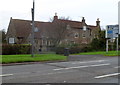
Village Hall and Old Vicarage, Falfield
Located alongside the A38. The village hall, on the left side of the tree, was formerly the village school. The hall belongs to the Diocese of Gloucester, who have leased it to Falfield Parish Council.
The Old Vicarage is on the right. http://www.geograph.org.uk/photo/2749719
Image: © Jaggery
Taken: 1 Jan 2012
0.09 miles
5

Quiet neighbours
St George's churchyard, Falfield.
Image: © Robin Stott
Taken: 16 Jul 2010
0.09 miles
6
Headstones and trees, Falfield, South Gloucestershire
In St George's churchyard in the Church of England Diocese of Gloucester.
Image: © Jaggery
Taken: 25 Sep 2022
0.10 miles
7
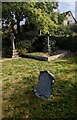
Churchyard crosses, Falfield, South Gloucestershire
In the NE corner of St George's churchyard in the Church of England Diocese of Gloucester.
Image: © Jaggery
Taken: 25 Sep 2022
0.10 miles
8
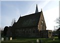
Falfield Church
St George's Church, Falfield, viewed from the churchyard.
Image: © Ruth Riddle
Taken: 28 Jan 2012
0.10 miles
9
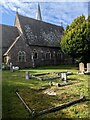
Church and churchyard, Falfield, South Gloucestershire
Looking towards the rear of Grade II Listed St George's Church
in the Church of England Diocese of Gloucester.
Image: © Jaggery
Taken: 25 Sep 2022
0.10 miles
10
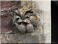
Boss, St George's Church, Falfield
On the church porch.
Image: © Eirian Evans
Taken: 17 Feb 2011
0.11 miles