IMAGES TAKEN NEAR TO
Hardwicke Close, WOTTON-UNDER-EDGE, GL12 8FE
Introduction
This page details the photographs taken nearby to Hardwicke Close, GL12 8FE by members of the Geograph project.
The Geograph project started in 2005 with the aim of publishing, organising and preserving representative images for every square kilometre of Great Britain, Ireland and the Isle of Man.

There are currently over 7.5m images from over14,400 individuals and you can help contribute to the project by visiting https://www.geograph.org.uk
Image Map
Images are licensed for reuse under creativecommons.org/licenses/by-sa/2.0
Notes
- Clicking on the map will re-center to the selected point.
- The higher the marker number, the further away the image location is from the centre of the postcode.
Image Listing (78 Images Found)
Images are licensed for reuse under creativecommons.org/licenses/by-sa/2.0
Image
Details
Distance
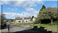
1
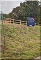
The Chestnuts information board, Tytherington, South Gloucestershire
In September 2023 the Milburys FOR SALE board on a bank
above Stowell Hill Road shows "A Select Development of 7 Homes"
Image: © Jaggery
Taken: 24 Sep 2023
0.03 miles
2
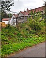
Fenced-off house under scaffolding, Tytherington, South Gloucestershire
Viewed from Stowell Hill Road in September 2023.
Image: © Jaggery
Taken: 24 Sep 2023
0.04 miles
3

Alice in Wonderland information board, Tytherington, South Gloucestershire
The board alongside Stowell Hill Road in September 2023 shows
ALICE IN WONDERLAND
7.30 19, 20, 21 OCTOBER
TYTHERINGTON VILLAGE HALL
Image: © Jaggery
Taken: 24 Sep 2023
0.05 miles
4
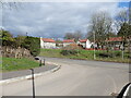
Junction of Clements Way with Stowell Hill Road, Tytherington
At time of photo some of the houses at Clements Way were still under construction.
Image: © Ruth Sharville
Taken: 26 Feb 2023
0.05 miles
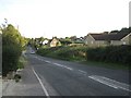
5
New Road, Tytherington, South Gloucestershire
Image: © Ruth Sharville
Taken: 26 Feb 2023
0.07 miles
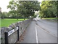
6
The junction of New Road with Stowell Hill Road, Tytherington
Image: © Ruth Sharville
Taken: 26 Feb 2023
0.08 miles
7
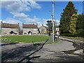
New Road name sign, Tytherington, South Gloucestershire
The sign at the Stowell Hill Road junction shows that New Road leads to Tytherington Hill.
Image: © Jaggery
Taken: 24 Sep 2023
0.09 miles
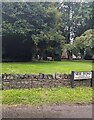
8
Stowell Hill Road, Tytherington: 2
On the left. a recreation ground and play area; on the right, the churchyard.
Image: © Robin Stott
Taken: 20 Sep 2010
0.10 miles
10
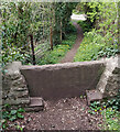
Stone Stile, Tytherington
On Gloucestershire footpath OTY/11, looking West towards houses "Brae Side" and "Tower Hill". The view East is Image
Image: © Lenneke Jansens
Taken: 9 Apr 2021
0.11 miles