IMAGES TAKEN NEAR TO
Mallow Road, WOTTON-UNDER-EDGE, GL12 8EL
Introduction
This page details the photographs taken nearby to Mallow Road, GL12 8EL by members of the Geograph project.
The Geograph project started in 2005 with the aim of publishing, organising and preserving representative images for every square kilometre of Great Britain, Ireland and the Isle of Man.

There are currently over 7.5m images from over14,400 individuals and you can help contribute to the project by visiting https://www.geograph.org.uk
Image Map
Images are licensed for reuse under creativecommons.org/licenses/by-sa/2.0
Notes
- Clicking on the map will re-center to the selected point.
- The higher the marker number, the further away the image location is from the centre of the postcode.
Image Listing (74 Images Found)
Images are licensed for reuse under creativecommons.org/licenses/by-sa/2.0
Image
Details
Distance
1
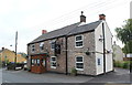
The Plough Inn, Wotton Road, Charfield, Gloucestershire 2014
Image: © Ray Bird
Taken: 11 Sep 2014
0.11 miles
2

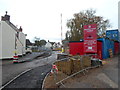
Coal yard, Charfield
The metal gate is at the Wotton Road edge of the 75 metre long coal yard of Jones Bros.
Image: © Jaggery
Taken: 28 Oct 2012
0.11 miles
3
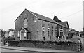
Congregational Church, Wotton Road, Charfield, Gloucestershire 2014
Image: © Ray Bird
Taken: 11 Sep 2014
0.11 miles
4
The Plough Inn, Wotton Road, Charfield, Gloucestershire 2014
Image: © Ray Bird
Taken: 11 Sep 2014
0.12 miles
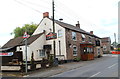
6

The Plough Inn Charfield viewed from the west
Located at 68 Wotton Road, the pub is one of three in the village.
http://www.geograph.org.uk/photo/3202048 to a view from the east.
Image: © Jaggery
Taken: 28 Oct 2012
0.14 miles
7
House construction site, Charfield
The site is on the south side of Wotton Road. The development began despite a petition signed by more than 200 people opposing the housing scheme on land behind Charfield Congregational Church. http://www.geograph.org.uk/photo/3201473
The property known as Kings Hall was demolished to provide access to the site.
Image: © Jaggery
Taken: 28 Oct 2012
0.14 miles
8
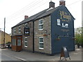
The Plough, Charfield
One of a few micro breweries that have sprung up in the area.
Image: © Neil Owen
Taken: 18 Apr 2019
0.14 miles
9

The Plough Inn Charfield viewed from the east
Located at 68 Wotton Road, the pub is one of three in the village.
http://www.geograph.org.uk/photo/3202041 to a view from the west.
Image: © Jaggery
Taken: 28 Oct 2012
0.14 miles
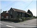
10
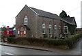
Charfield Congregational Church
On the corner of Wotton Road and Elbury View, Charfield.
Image: © Jaggery
Taken: 28 Oct 2012
0.15 miles