IMAGES TAKEN NEAR TO
Heneage Lane, WOTTON-UNDER-EDGE, GL12 8DN
Introduction
This page details the photographs taken nearby to Heneage Lane, GL12 8DN by members of the Geograph project.
The Geograph project started in 2005 with the aim of publishing, organising and preserving representative images for every square kilometre of Great Britain, Ireland and the Isle of Man.

There are currently over 7.5m images from over14,400 individuals and you can help contribute to the project by visiting https://www.geograph.org.uk
Image Map
Images are licensed for reuse under creativecommons.org/licenses/by-sa/2.0
Notes
- Clicking on the map will re-center to the selected point.
- The higher the marker number, the further away the image location is from the centre of the postcode.
Image Listing (33 Images Found)
Images are licensed for reuse under creativecommons.org/licenses/by-sa/2.0
Image
Details
Distance
1

Stile to a public footpath, Heneage Lane, Falfield
Located between the A38 to the west and Heneage Court to the east.
Image: © Jaggery
Taken: 1 Jan 2012
0.04 miles
2
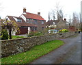
Heneage Lane houses, Falfield
Located between the A38 to the west and Heneage Court to the east (ahead).
Image: © Jaggery
Taken: 1 Jan 2012
0.04 miles
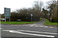
4
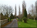
Entrance driveway to Heneage Court, Falfield
View taken from the public road, Heneage Lane, looking towards the private driveway into Heneage Court.
Image: © Jaggery
Taken: 1 Jan 2012
0.06 miles
5
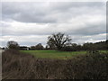
Oak Tree in field near Falfield
To east of A38
Image: © Alex McGregor
Taken: 27 Mar 2010
0.07 miles
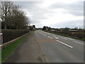
6
Northern boundary of Falfield
The A38 enters the South Gloucestershire village of Falfield.
Image: © Jaggery
Taken: 1 Jan 2012
0.08 miles
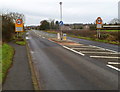
7
Heneage Lane, Falfield
Heneage Lane heads away from the A38, towards Heneage Court.
Image: © Jaggery
Taken: 1 Jan 2012
0.09 miles
8
A38 Falfield
Viewed from entrance to The Gables Hotel
Image: © Alex McGregor
Taken: 27 Mar 2010
0.09 miles
9
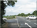
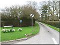
Moorslade Lane joins A38 north of Falfield
These two empty stretch limos appeared – heaven knows where from.
Image: © Robin Stott
Taken: 16 Jul 2010
0.10 miles
10
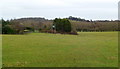
Public footpath across a field, Heneage Lane, Falfield
It's not clear exactly where the footpath is, but a sign http://www.geograph.org.uk/photo/2749830 on the stile behind the camera shows that there is one across this field.
Image: © Jaggery
Taken: 1 Jan 2012
0.11 miles