IMAGES TAKEN NEAR TO
Church Avenue, WOTTON-UNDER-EDGE, GL12 8BY
Introduction
This page details the photographs taken nearby to Church Avenue, GL12 8BY by members of the Geograph project.
The Geograph project started in 2005 with the aim of publishing, organising and preserving representative images for every square kilometre of Great Britain, Ireland and the Isle of Man.

There are currently over 7.5m images from over14,400 individuals and you can help contribute to the project by visiting https://www.geograph.org.uk
Image Map
Images are licensed for reuse under creativecommons.org/licenses/by-sa/2.0
Notes
- Clicking on the map will re-center to the selected point.
- The higher the marker number, the further away the image location is from the centre of the postcode.
Image Listing (65 Images Found)
Images are licensed for reuse under creativecommons.org/licenses/by-sa/2.0
Image
Details
Distance
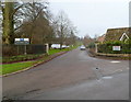
1

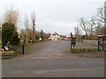
Church Avenue, Falfield
Signs indicate that Church Avenue is a private road within the curtilage of HM Prison Eastwood Park. Beyond the old lodge is a small housing estate, presumably for prison staff and their families. The view is from the south side of St George's Church across Sundayshill Lane. Eastwood Park is a female closed local prison http://en.wikipedia.org/wiki/Eastwood_Park_(HM_Prison) A Google search is instructive.
Image: © Robin Stott
Taken: 16 Jul 2010
0.02 miles
2
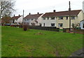
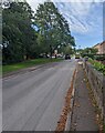
Orchard View houses, Falfield
The houses are set back from the north side of Sundayshill Lane.
Image: © Jaggery
Taken: 1 Jan 2012
0.04 miles
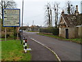
3
Private road to H.M. Prison, Eastwood Park
Viewed from Sundayshill Lane, Falfield. Shown on maps as Church Avenue, the road leads to H.M. Prison Eastwood Park, a women's closed category prison.
Image: © Jaggery
Taken: 1 Jan 2012
0.04 miles
4
Large sign, Sundayshill Lane, Falfield
Three groups of three choices are displayed on the sign at the approach to the A38 in the Gloucestershire village of Falfield. Grade II listed Falfield Lodge http://www.geograph.org.uk/photo/2749639 is on the right.
Image: © Jaggery
Taken: 1 Jan 2012
0.05 miles
5
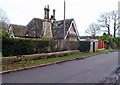
Grade II listed Falfield Lodge, Falfield
Early 19th century building in the Tudor Gothic style, located on the corner of Church Avenue and Sundayshill Lane. Prominent features are three turret-like ornate chimneys.
Grade II listed in June 1984.
Image: © Jaggery
Taken: 1 Jan 2012
0.05 miles
6
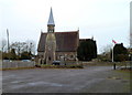
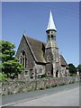
St George's Parish Church, Falfield
Viewed from the south, along the Huntsman Inn car park and across Sundayshill Lane.
The church was built in 1859-1860. Grade II listed in June 1984.
Image: © Jaggery
Taken: 1 Jan 2012
0.05 miles
8
Church Avenue, Falfield
Viewed from the corner of Sundayshill Lane. A sign in the background shows "Residential Area" and a 15 mph speed limit.
Image: © Jaggery
Taken: 25 Sep 2022
0.05 miles
9
Car park, The Huntsman Inn, Falfield
Viewed from Sundayshill Lane. The car park, measuring about 65 metres by 20 metres, is on the north side of the inn. http://www.geograph.org.uk/photo/2749348
Image: © Jaggery
Taken: 1 Jan 2012
0.05 miles
10
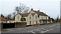
The Huntsman Inn, Falfield
Located alongside the A38 in the village of Falfield, South Gloucestershire.
The inn traces its origins to the 17th century. It has been used as a meeting place for the Berkeley Hunt, and as a changeover point to use fresh horses and hounds.
Image: © Jaggery
Taken: 1 Jan 2012
0.05 miles