IMAGES TAKEN NEAR TO
Bagstone, WOTTON-UNDER-EDGE, GL12 8BB
Introduction
This page details the photographs taken nearby to GL12 8BB by members of the Geograph project.
The Geograph project started in 2005 with the aim of publishing, organising and preserving representative images for every square kilometre of Great Britain, Ireland and the Isle of Man.

There are currently over 7.5m images from over14,400 individuals and you can help contribute to the project by visiting https://www.geograph.org.uk
Image Map
Images are licensed for reuse under creativecommons.org/licenses/by-sa/2.0
Notes
- Clicking on the map will re-center to the selected point.
- The higher the marker number, the further away the image location is from the centre of the postcode.
Image Listing (5 Images Found)
Images are licensed for reuse under creativecommons.org/licenses/by-sa/2.0
Image
Details
Distance
1
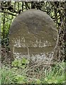
Old Milestone by the B4058, Bagstone Road, Rangeworthy parish
Carved stone post by the B4058, in parish of RANGEWORTHY (SOUTH GLOUCESTERSHIRE District), Bagstone Road; North of Winpenny Bridge, South of path junctions, against hedge, on East side of road. Wotton stone, erected by the Wotton-under-Edge (Division) turnpike trust in the 18th century. Defaced.
Inscription reads:-
VI
Miles from
(WOTTON)
Grade II listed.
List Entry Number: 1137106 https://historicengland.org.uk/listing/the-list/list-entry/1137106
Milestone Society National ID: GL_WERY06.
Image: © M Faherty
Taken: 11 Apr 2010
0.02 miles
2
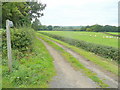
Track and footpath to Ashworthy Farm
Looking west from the B4058 Wotton Road between Bagstone and Heath End.
Image: © Jonathan Billinger
Taken: 24 Sep 2010
0.04 miles
3
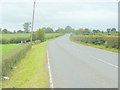
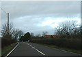
B4058 Bagstone Road
Looking north towards Heath End.
Image: © Jonathan Billinger
Taken: 24 Sep 2010
0.12 miles
4
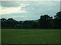
Towards Tytherington
Looking west across the square towards Tytherington.
Image: © Chris Shaw
Taken: Unknown
0.16 miles
5
Bristol Road B4058
The B4058 looking north east towards the premises of JB Motors, which has yellow signs by the roadside to highlight the location of the entrance drive.
Image: © Ruth Riddle
Taken: 9 Jan 2012
0.24 miles