IMAGES TAKEN NEAR TO
Heathend, WOTTON-UNDER-EDGE, GL12 8AS
Introduction
This page details the photographs taken nearby to GL12 8AS by members of the Geograph project.
The Geograph project started in 2005 with the aim of publishing, organising and preserving representative images for every square kilometre of Great Britain, Ireland and the Isle of Man.

There are currently over 7.5m images from over14,400 individuals and you can help contribute to the project by visiting https://www.geograph.org.uk
Image Map
Images are licensed for reuse under creativecommons.org/licenses/by-sa/2.0
Notes
- Clicking on the map will re-center to the selected point.
- The higher the marker number, the further away the image location is from the centre of the postcode.
Image Listing (5 Images Found)
Images are licensed for reuse under creativecommons.org/licenses/by-sa/2.0
Image
Details
Distance
1
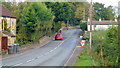
Heath End
The B4058 heads north over a small brook at Cole's Bridge.
Image: © Jonathan Billinger
Taken: 19 Oct 2012
0.05 miles
2
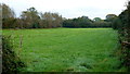
Small field by Cole's Bridge
East of the B4058 at Heath End.
Image: © Jonathan Billinger
Taken: 19 Oct 2012
0.10 miles
3
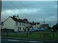
Heath End cottages
Looking East at Heath End, in the NE of the square
Image: © Chris Shaw
Taken: Unknown
0.16 miles
4
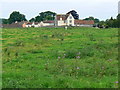
Footpath towards Heath End
The footpath stretches from the viewpoint towards the housing in the background. Although signposted, the path is hard to discern on the ground.
Image: © Brian Robert Marshall
Taken: 5 Jul 2007
0.21 miles
5
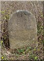
Old Milestone by the B4058, Heath End, Cromhall
Carved stone post by the B4058, in parish of CROMHALL (SOUTH GLOUCESTERSHIRE District), Heath End, just North of Ivy Cottage by footpath sign on verge, on East side of road. Wotton stone, erected by the Wotton-under-Edge (Division) turnpike trust in the 18th century.
Inscription reads:-
: (V) / M(iles fr)om / (WOTTON) :
Carved benchmark front upper, rivet on top.
Grade II listed. List Entry Number: 1321197
https://historicengland.org.uk/listing/the-list/list-entry/1321197
Milestone Society National ID: GL_WERY05.
Image: © M Faherty
Taken: 11 Apr 2010
0.24 miles