IMAGES TAKEN NEAR TO
Longcross, WOTTON-UNDER-EDGE, GL12 8AP
Introduction
This page details the photographs taken nearby to Longcross, GL12 8AP by members of the Geograph project.
The Geograph project started in 2005 with the aim of publishing, organising and preserving representative images for every square kilometre of Great Britain, Ireland and the Isle of Man.

There are currently over 7.5m images from over14,400 individuals and you can help contribute to the project by visiting https://www.geograph.org.uk
Image Map
Images are licensed for reuse under creativecommons.org/licenses/by-sa/2.0
Notes
- Clicking on the map will re-center to the selected point.
- The higher the marker number, the further away the image location is from the centre of the postcode.
Image Listing (30 Images Found)
Images are licensed for reuse under creativecommons.org/licenses/by-sa/2.0
Image
Details
Distance
1
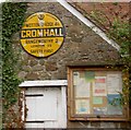
Historic AA road sign for Cromhall village
I presume there are few signs left in their original location?
Image: © Steve Fareham
Taken: 11 Nov 2009
0.06 miles
2
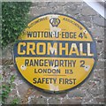
Old circular AA sign in Cromhall
Old AA Sign set on the gable end of an outhouse in Cromhall, 4¾ miles southeast of Wotton, on the south side of a minor road from the B4058 to Talbot's End. Cromhall parish.
This is the Circular, village name on black band, no Motor Union symbol or name type, dating from 1923, showing distances Wooton-U-Edge 4¾ Rangeworthy 2 London 113. Removed by 2019.
There were five series of AA signs, mostly dating from 1923 and made by Francis & Co / Franco in Deptford, London. The village name and distance to London or Dublin were normally displayed.
See also https://www.geograph.org.uk/photo/1577597 , https://www.flickr.com/photos/rockmanzym/4714040788 and https://www.flickr.com/photos/16346837@N06/16043315894.
Milestone Society National ID: GL-CROMH
Image: © Milestone Society
Taken: Unknown
0.07 miles
3
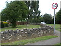
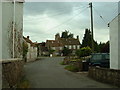
Cromhall crossroads
This part of the village lies right on the Bristol Road, but is a fairly new addition to the landscape. In earlier years the road was a few metres to the east but the realignment on the 1950s gave the chance to create this small but pleasant little grassed area. On the short wall is a benchmark of similar vintage - see Image
Image: © Neil Owen
Taken: 8 Aug 2019
0.07 miles
4
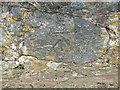
Benchmark at the Cromhall crossroads
Where the Bristol Road meets Church Lane in Cromhall marks the home of a fairly new benchmark on the short wall of a small grass area. See https://www.bench-marks.org.uk/bm110322 for the entry in the Benchmark Database, or Image] for a look at the patch of land.
Image: © Neil Owen
Taken: 8 Aug 2019
0.07 miles
5
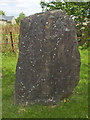
Cromhall's millennium stone
Bearing the date '2000', which is not only vertical but also not in Roman numerals. See Image] for a wider view under the tree at the junction of the Bristol Road and Talbots End.
Image: © Neil Owen
Taken: 8 Aug 2019
0.08 miles
6
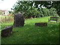
Millennium stones and a bench
Cromhall has marked the year 2000 with a large stone and two small stones on the small patch of grass at the crossroads. The bench seat is actually a bit newer, marking the village's celebration of the Queen's Golden Jubilee.
Image: © Neil Owen
Taken: 8 Aug 2019
0.08 miles
9
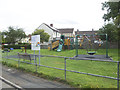
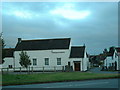
Townwell Play Area
The children of the small village have this rather splendid area to enjoy. Previously there was a sewage plant here and before that, allotments.
Image: © Neil Owen
Taken: 8 Aug 2019
0.17 miles
10
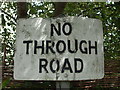
Battered 'No Through Road' sign
This old road sign had seen better days.
Image: © Neil Owen
Taken: 8 Aug 2019
0.18 miles