IMAGES TAKEN NEAR TO
Rectory Lane, WOTTON-UNDER-EDGE, GL12 8AN
Introduction
This page details the photographs taken nearby to Rectory Lane, GL12 8AN by members of the Geograph project.
The Geograph project started in 2005 with the aim of publishing, organising and preserving representative images for every square kilometre of Great Britain, Ireland and the Isle of Man.

There are currently over 7.5m images from over14,400 individuals and you can help contribute to the project by visiting https://www.geograph.org.uk
Image Map
Images are licensed for reuse under creativecommons.org/licenses/by-sa/2.0
Notes
- Clicking on the map will re-center to the selected point.
- The higher the marker number, the further away the image location is from the centre of the postcode.
Image Listing (4 Images Found)
Images are licensed for reuse under creativecommons.org/licenses/by-sa/2.0
Image
Details
Distance
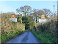
3
Slow down for Cromhall
The 30 mph signs look out of place on such a narrow country lane.
Image: © Steve Fareham
Taken: 31 Mar 2009
0.14 miles
4
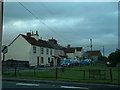
Heath End cottages
Looking East at Heath End, in the NE of the square
Image: © Chris Shaw
Taken: Unknown
0.23 miles