IMAGES TAKEN NEAR TO
Ozleworth, WOTTON-UNDER-EDGE, GL12 7QB
Introduction
This page details the photographs taken nearby to GL12 7QB by members of the Geograph project.
The Geograph project started in 2005 with the aim of publishing, organising and preserving representative images for every square kilometre of Great Britain, Ireland and the Isle of Man.

There are currently over 7.5m images from over14,400 individuals and you can help contribute to the project by visiting https://www.geograph.org.uk
Image Map
Images are licensed for reuse under creativecommons.org/licenses/by-sa/2.0
Notes
- Clicking on the map will re-center to the selected point.
- The higher the marker number, the further away the image location is from the centre of the postcode.
Image Listing (12 Images Found)
Images are licensed for reuse under creativecommons.org/licenses/by-sa/2.0
Image
Details
Distance
1
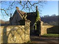
Lower Lodge, Ozleworth Park
Perhaps confusingly, there are two Lower Lodges within a mile of each other; Newark Park's Lower Lodge is further down the valley. Both are listed buildings; this lodge dates from 1853 http://www.imagesofengland.org.uk/Details/Default.aspx?id=426908&mode=adv . The gate piers and flanking wall are also listed, although the eagles, presumably more recent, aren't mentioned http://www.imagesofengland.org.uk/Details/Default.aspx?id=426909&mode=adv .
Image: © Derek Harper
Taken: 1 Jan 2010
0.01 miles
2
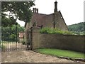
Lower Lodge
Lower Lodge, Ozleworth Bottom.
Image: © Alan Hughes
Taken: 9 Jul 2016
0.01 miles
3
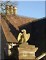
Eagle gatepost, Ozleworth Park
"This one appears to be riff-raff, don't you think?". This ill-tempered looking bird is on top of one of the listed gateposts shown in Image The roof of the Lower Lodge, with its crested ridge tiles, is behind.
Image: © Derek Harper
Taken: 1 Jan 2010
0.01 miles
4
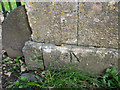
Benchmark on lodge gatepost
The OS description is GTP NE SIDE RD SE SIDE ENT LOWER LODGE. The mark is clearly visible in the largest size image available in Image
Image: © Neville Goodman
Taken: 5 Sep 2020
0.01 miles
6
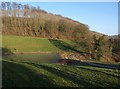
Public access route to Ozleworth Bottom
The route drops down a fairly steep slope to the picturesquely named Ozleworth Bottom.
Image: © Brian Robert Marshall
Taken: 22 Apr 2008
0.04 miles
7
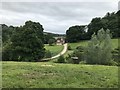
Lake beside Lower Lodge, Ozleworth
Bridleway NOZ/10/1 curves across the foot of the lake from Ozleworth Park's Lower Lodge. The lake occupies the lower part of the combe southwest of Ozleworth; the combe opens into Ozleworth Bottom on the right of the image. On the far side of the combe is Park Wood. Seen from the foot of Blacksmith Hill just above the lodge.
Image: © Derek Harper
Taken: 1 Jan 2010
0.05 miles
8
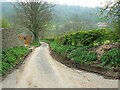
The road to Wotton under Edge, Ozleworth Bottom
Yet another narrow and rather muddy country lane in the Cotswolds. This one leads to Wotton under Edge, eventually. The steep track to the left is a right of way.
Image: © Brian Robert Marshall
Taken: 22 Apr 2008
0.06 miles
9
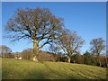
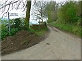
Oaks in Ozleworth Bottom
Footpath NOZ/11/1 climbs past these oaks to meet the lane at Image (left).
Image: © Derek Harper
Taken: 1 Jan 2010
0.09 miles
10
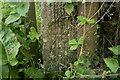
Benchmark covered by moss
The OS description is STO GTP SW SIDE RD. Not all these stone gateposts from the 1950s or earlier have survived, and their benchmarks have died with them. This one needed a bit of gardening to find. The gatepost is in Image
Image: © Neville Goodman
Taken: 5 Sep 2020
0.11 miles