IMAGES TAKEN NEAR TO
Wortley Road, WOTTON-UNDER-EDGE, GL12 7NX
Introduction
This page details the photographs taken nearby to Wortley Road, GL12 7NX by members of the Geograph project.
The Geograph project started in 2005 with the aim of publishing, organising and preserving representative images for every square kilometre of Great Britain, Ireland and the Isle of Man.

There are currently over 7.5m images from over14,400 individuals and you can help contribute to the project by visiting https://www.geograph.org.uk
Image Map
Images are licensed for reuse under creativecommons.org/licenses/by-sa/2.0
Notes
- Clicking on the map will re-center to the selected point.
- The higher the marker number, the further away the image location is from the centre of the postcode.
Image Listing (236 Images Found)
Images are licensed for reuse under creativecommons.org/licenses/by-sa/2.0
Image
Details
Distance
1
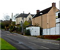
Wortley Road, Wotton-under-Edge
Viewed from near the corner of Water Lane and new houses. http://www.geograph.org.uk/photo/3732045
Image: © Jaggery
Taken: 28 Oct 2012
0.01 miles
2
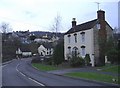
Dyers Brook House, Wotton-under-edge
At the south eastern entrance to the town centre.
Image: © Roger Cornfoot
Taken: 19 Feb 2007
0.02 miles
3
New houses in Wotton-under-Edge
On the corner of Water Lane and Wortley Road, part of the Mill Brook development by Elan Homes.
Image: © Jaggery
Taken: 28 Oct 2012
0.03 miles
4
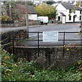
Depositing rubbish in this stream is forbidden, Wotton-under-Edge
The Wotton-under-Edge town council notice is on a fence alongside Dyers Brook.
Image: © Jaggery
Taken: 28 Oct 2012
0.05 miles
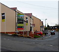
5
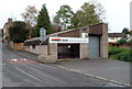
Colour-Tech accident repair centre, Wotton-under-Edge
Located in a street named Dyers Brook, alongside a brook http://www.geograph.org.uk/photo/3732024 of the same name.
Image: © Jaggery
Taken: 28 Oct 2012
0.05 miles
6
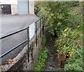
Dyers Brook, Wotton-under-Edge
Viewed from the street also named Dyers Brook.
Colour-Tech accident repair centre http://www.geograph.org.uk/photo/3732013 is on the left.
Image: © Jaggery
Taken: 28 Oct 2012
0.05 miles
7
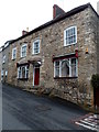
Former Shearmans Arms in Wotton-under-Edge
Built in the early 19th century, number 5 School Road,
at the bottom of Ludgate Hill, was for decades the Shearmans Arms Inn.
Image: © Jaggery
Taken: 28 Oct 2012
0.09 miles
8
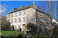
Waterloo Mill - Wotton-under-Edge
Textile mill built as a steam mill in 1815. Now converted to dwellings. There is an 1815 datestone on this elevation.
Image: © Chris Allen
Taken: 10 Mar 2019
0.09 miles
9
The Ram Inn (closed), Wotton Under Edge, Gloucestershire 2015
Reputed to be one of the most haunted buildings in England.
Image: © Ray Bird
Taken: 11 Sep 2015
0.09 miles
10
The Ram Inn (closed), Wotton Under Edge, Gloucestershire 2015
Notice in Ram Inn window. Reputed to be one of the most haunted buildings in England.
Image: © Ray Bird
Taken: 11 Sep 2015
0.09 miles