IMAGES TAKEN NEAR TO
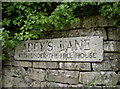
Adeys Lane, WOTTON-UNDER-EDGE, GL12 7LY
Introduction
This page details the photographs taken nearby to Adeys Lane, GL12 7LY by members of the Geograph project.
The Geograph project started in 2005 with the aim of publishing, organising and preserving representative images for every square kilometre of Great Britain, Ireland and the Isle of Man.

There are currently over 7.5m images from over14,400 individuals and you can help contribute to the project by visiting https://www.geograph.org.uk
Image Map
Images are licensed for reuse under creativecommons.org/licenses/by-sa/2.0
Notes
- Clicking on the map will re-center to the selected point.
- The higher the marker number, the further away the image location is from the centre of the postcode.
Image Listing (143 Images Found)
Images are licensed for reuse under creativecommons.org/licenses/by-sa/2.0
Image
Details
Distance
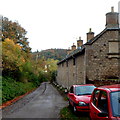
1
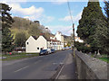
Adey's Lane, Wotton-under-Edge
Adey's Lane heads away from Coombe Road towards Old London Road.
Image: © Jaggery
Taken: 28 Oct 2012
0.05 miles
2
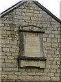
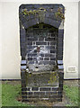
In Honorem Sanctae Trinitatis
An inscribed stone high in the gable wall of the almshouses opposite Parklands, detailing the gift by the delightfully named Miss Ann Bearpacker in 1837. See Image] for some more views.
Image: © Neil Owen
Taken: 2 Aug 2014
0.09 miles
3
Just watered
Some fine flowers and plants grown by occupants of the almshouses, which have been blessed by a summer downpour. See Image] for details of the benefactor.
Image: © Neil Owen
Taken: 2 Aug 2014
0.09 miles
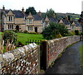
4
Five Bearpacker almshouses, Wotton-under-Edge
Viewed along Adey's Lane. In view are 5 of 10 Bearpacker almshouses. The inscription on the side wall states that the almshouses (described as tenements) with the gardens adjacent were given by
Miss A Bearpacker for the occupation of five poor and infirm men, old inhabitants of the parish of Wotton-under-Edge and members of the established Church of England.
The year shown is MDCCCXXXVII (1837).
http://www.geograph.org.uk/photo/3811198 to the other 5 almshouses.
Image: © Jaggery
Taken: 28 Oct 2012
0.10 miles
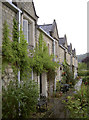
5
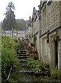
Steps up the almshouses
The almshouses were established in 1837 and were recently refurbished to bring them up to modern standards, but keeping the essential character. See Image] for a look at the far row of houses.
Image: © Neil Owen
Taken: 2 Aug 2014
0.11 miles
6
Five of ten Bearpacker almshouses, Wotton-under-Edge
See http://www.geograph.org.uk/photo/3811137 for a view of the other five and details of the inscription.
Image: © Jaggery
Taken: 28 Oct 2012
0.12 miles
7
Adey's Lane
Including an unusual reference to a certain house.
Image: © Neil Owen
Taken: 2 Aug 2014
0.12 miles
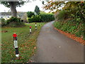
8
Edbrooke Spring
Wotton-under-Edge used to have a fresh water supply running off the hills beyond. This modern trough is on the site of the original spring that supplied the town in times past.
Image: © Neil Owen
Taken: 2 Aug 2014
0.13 miles
9
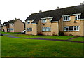
Parklands houses in Wotton-under-Edge
Parklands is an area of about 100 houses on the NW side of the B4058 Culverhay.
Image: © Jaggery
Taken: 28 Oct 2012
0.13 miles